Saint-Romain-de-Colbosc geodata
Saint-Romain-de-Colbosc (Normandy) is a populated place; located in France in Europe/Paris (GMT+2) time zone. With population of 4,052 people, there are 2424 cities with bigger population in this country. Compared to other cities in France, 89.7% of cities are located further ↓South; 74.7% of cities are located further →East and 54.4% of cities have higher elevation than Saint-Romain-de-Colbosc. Note1
Administrative division(s):
- Level 1: Normandy
- Level 2: Seine-Maritime
- Level 3: Arrondissement du Havre
- Level 4: Saint-Romain-de-Colbosc
Current local time in Saint-Romain-de-Colbosc:
05:51 AM, WednesdayDifference from your time zone: hours


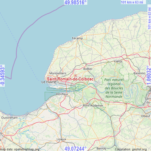
Saint-Romain-de-Colbosc GPS coordinates[2]
49° 31' 51.348" North, 0° 21' 25.884" East
| Map corner | latitude | longitude |
|---|---|---|
| Upper-left | 49.98516°, | -0.34593° |
| Center: | 49.53093°, | 0.35719° |
| Lower-right: | 49.07244°, | 1.06032° |
| Map W x H: | 101.5×101.5 km | = 63.1×63.1mi |
| max Lat: | 51.07786° ⇑10.3% North |
| Saint-Romain-de-Colbosc: | 49.53093° |
| min Lat: | ⇓89.7% South 41.3874° |
| min Long | Saint-Romain-de | max Long |
| -5.08615° | 0.35719° | 9.52242° |
| W 25.3%⇐ | ⇒74.7% E |
Elevation
Elevation of Saint-Romain-de-Colbosc is 118 m = 387 ft, and this is 75.7 m = 248 ft below average elevation for this country.
| Max E: |
2333 m = 7654 ft | 54.4% |
| Avg. | 193.7 m = 635 ft | |
| Saint-Romain-de-Colbosc | 118 m = 387 ft | |
Min E: |
-1 m = -3 ft | 45.6% |
See also: France elevation on elevation.city.
Geographical zone
Saint-Romain-de-Colbosc is located in North temperate zone (between Tropic of Cancer and the Arctic Circle). Distance of this North polar circle is 1893.9 km =1176.8 mi to North.| Distance of | km | miles | from Saint-Romain-de-Colbosc |
|---|---|---|---|
| North Pole | 4499.7 | 2796 | to North |
| Arctic Circle | 1893.9 | 1176.8 | to North |
| Tropic Cancer | 2901.4 | 1802.8 | to South |
| Equator | 5507.3 | 3422.1 | to South |


Nearby cities:
15 places around Saint-Romain-de-Colbosc: (largest is in red/bold)
• Gainneville
7 km =4.3 mi,  258°
258°
• Gommerville
2.9 km =1.8 mi,  16°
16°
• Graimbouville
5.3 km =3.3 mi,  340°
340°
• La Cerlangue
4.9 km =3 mi,  124°
124°
• La Remuée
3.3 km =2.1 mi,  96°
96°
• Les Trois-Pierres
4.8 km =3 mi,  63°
63°
• Mélamare
7.1 km =4.4 mi,  84°
84°
• Rogerville
7.3 km =4.5 mi,  244°
244°
• Sainneville
5.7 km =3.5 mi,  299°
299°
• Saint-Aubin-Routot
2.4 km =1.5 mi,  249°
249°
• Saint-Gilles-de-la-Neuville
5.1 km =3.2 mi, 15°
• Saint-Vincent-Cramesnil
3.1 km =1.9 mi,  175°
175°
• Sandouville
4.7 km =2.9 mi,  217°
217°
• Épretot
3.1 km =1.9 mi,  286°
286°
• Étainhus
5.1 km =3.2 mi,  321°
321°
Sources, notices
• [Note1] Compared only with cities in France existing in our database
• [Src1] Map data: © OpenStreetMap contributors (CC-BY-SA)
• [Src2] Other city data from geonames.org with taken over terms of usage.
• [Src3] Geographical zone / Annual Mean Temperature by Robert A. Rohde @ Wikipedia
