Survilliers geodata
Survilliers (Île-de-France) is a populated place; located in France in Europe/Paris (GMT+2) time zone. With population of 3,869 people, there are 2541 cities with bigger population in this country. Compared to other cities in France, 82.1% of cities are located further ↓South; 51.3% of cities are located further ←West and 52.8% of cities have lower elevation than Survilliers. Note1
Administrative division(s):
- Level 1: Île-de-France
- Level 2: Département du Val-d’Oise
- Level 3: Arrondissement de Sarcelles
- Level 4: Survilliers


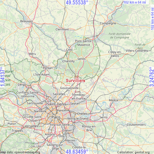
Survilliers GPS coordinates[2]
49° 5' 49.632" North, 2° 32' 40.164" East
| Map corner | latitude | longitude |
|---|---|---|
| Upper-left | 49.55538°, | 1.84137° |
| Center: | 49.09712°, | 2.54449° |
| Lower-right: | 48.63459°, | 3.24762° |
| Map W x H: | 102.4×102.4 km | = 63.6×63.6mi |
| max Lat: | 51.07786° ⇑17.9% North |
| Survilliers: | 49.09712° |
| min Lat: | ⇓82.1% South 41.3874° |
| min Long | Survilliers | max Long |
| -5.08615° | 2.54449° | 9.52242° |
| W 51.3%⇐ | ⇒48.7% E |
Elevation
Elevation of Survilliers is 142 m = 466 ft, and this is 51.7 m = 170 ft below average elevation for this country.
| Max E: |
2333 m = 7654 ft | 47.2% |
| Avg. | 193.7 m = 635 ft | |
| Survilliers | 142 m = 466 ft | |
Min E: |
-1 m = -3 ft | 52.8% |
See also: France elevation on elevation.city.
Geographical zone
Survilliers is located in North temperate zone (between Tropic of Cancer and the Arctic Circle). Distance of this North polar circle is 1942.1 km =1206.8 mi to North.| Distance of | km | miles | from Survilliers |
|---|---|---|---|
| North Pole | 4548 | 2826 | to North |
| Arctic Circle | 1942.1 | 1206.8 | to North |
| Tropic Cancer | 2853.2 | 1772.9 | to South |
| Equator | 5459.1 | 3392.1 | to South |


Nearby cities:
15 places around Survilliers: (largest is in red/bold)
• Bellefontaine
5.7 km =3.5 mi,  270°
270°
• Coye-la-Forêt
7.4 km =4.6 mi,  312°
312°
• Fosses
2.5 km =1.6 mi, 272°
• La Chapelle-en-Serval
3.6 km =2.2 mi,  347°
347°
• Louvres
6.5 km =4 mi,  206°
206°
• Marly-la-Ville
3.4 km =2.1 mi,  240°
240°
• Moussy-le-Neuf
5.6 km =3.5 mi,  130°
130°
• Orry-la-Ville
4.7 km =2.9 mi,  329°
329°
• Plailly
3.1 km =1.9 mi,  77°
77°
• Pontarmé
6.3 km =3.9 mi,  3°
3°
• Puiseux-en-France
5.6 km =3.5 mi, 214°
• Saint-Witz
2.1 km =1.3 mi,  109°
109°
• Thiers-sur-Thève
6.4 km =4 mi,  17°
17°
• Villeron
4.4 km =2.7 mi,  181°
181°
• Vémars
3.5 km =2.2 mi,  152°
152°
Sources, notices
• [Note1] Compared only with cities in France existing in our database
• [Src1] Map data: © OpenStreetMap contributors (CC-BY-SA)
• [Src2] Other city data from geonames.org with taken over terms of usage.
• [Src3] Geographical zone / Annual Mean Temperature by Robert A. Rohde @ Wikipedia
