Saint-Witz geodata
Saint-Witz (Île-de-France) is a populated place; located in France in Europe/Paris (GMT+2) time zone. With population of 2,354 people, there are 4105 cities with bigger population in this country. Compared to other cities in France, 81.9% of cities are located further ↓South; 51.7% of cities are located further ←West and 58.3% of cities have lower elevation than Saint-Witz. Note1
Administrative division(s):
- Level 1: Île-de-France
- Level 2: Département du Val-d’Oise
- Level 3: Arrondissement de Sarcelles
- Level 4: Saint-Witz


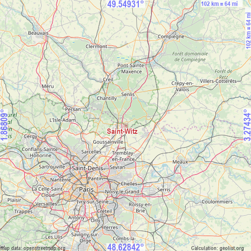
Saint-Witz GPS coordinates[2]
49° 5' 27.6" North, 2° 34' 16.392" East
| Map corner | latitude | longitude |
|---|---|---|
| Upper-left | 49.54931°, | 1.86809° |
| Center: | 49.091°, | 2.57122° |
| Lower-right: | 48.62842°, | 3.27434° |
| Map W x H: | 102.4×102.4 km | = 63.6×63.6mi |
| max Lat: | 51.07786° ⇑18.1% North |
| Saint-Witz: | 49.091° |
| min Lat: | ⇓81.9% South 41.3874° |
| min Long | Saint-Witz | max Long |
| -5.08615° | 2.57122° | 9.52242° |
| W 51.7%⇐ | ⇒48.3% E |
Elevation
Elevation of Saint-Witz is 162 m = 531 ft, and this is 31.7 m = 104 ft below average elevation for this country.
| Max E: |
2333 m = 7654 ft | 41.7% |
| Avg. | 193.7 m = 635 ft | |
| Saint-Witz | 162 m = 531 ft | |
Min E: |
-1 m = -3 ft | 58.3% |
See also: France elevation on elevation.city.
Geographical zone
Saint-Witz is located in North temperate zone (between Tropic of Cancer and the Arctic Circle). Distance of this North polar circle is 1942.8 km =1207.2 mi to North.| Distance of | km | miles | from Saint-Witz |
|---|---|---|---|
| North Pole | 4548.7 | 2826.4 | to North |
| Arctic Circle | 1942.8 | 1207.2 | to North |
| Tropic Cancer | 2852.5 | 1772.5 | to South |
| Equator | 5458.4 | 3391.7 | to South |


Nearby cities:
15 places around Saint-Witz: (largest is in red/bold)
• Bellefontaine
7.7 km =4.8 mi,  275°
275°
• Fosses
4.6 km =2.9 mi, 279°
• La Chapelle-en-Serval
5 km =3.1 mi,  326°
326°
• Louvres
7.1 km =4.4 mi,  223°
223°
• Marly-la-Ville
5 km =3.1 mi,  258°
258°
• Moussy-le-Neuf
3.7 km =2.3 mi,  142°
142°
• Moussy-le-Vieux
6.3 km =3.9 mi, 141°
• Orry-la-Ville
6.4 km =4 mi,  317°
317°
• Plailly
1.7 km =1.1 mi,  38°
38°
• Pontarmé
7.1 km =4.4 mi,  347°
347°
• Puiseux-en-France
6.5 km =4 mi,  232°
232°
• Survilliers
2.1 km =1.3 mi,  289°
289°
• Thiers-sur-Thève
6.8 km =4.2 mi,  359°
359°
• Villeron
4.3 km =2.7 mi,  209°
209°
• Vémars
2.4 km =1.5 mi,  188°
188°
Sources, notices
• [Note1] Compared only with cities in France existing in our database
• [Src1] Map data: © OpenStreetMap contributors (CC-BY-SA)
• [Src2] Other city data from geonames.org with taken over terms of usage.
• [Src3] Geographical zone / Annual Mean Temperature by Robert A. Rohde @ Wikipedia
