Plailly geodata
Plailly (Hauts-de-France) is a populated place; located in France in Europe/Paris (GMT+2) time zone. With population of 1,661 people, there are 5634 cities with bigger population in this country. Compared to other cities in France, 82.2% of cities are located further ↓South; 51.9% of cities are located further ←West and 58.7% of cities have higher elevation than Plailly. Note1
Administrative division(s):
- Level 1: Hauts-de-France
- Level 2: Département de l'Oise
- Level 3: Arrondissement de Senlis
- Level 4: Plailly


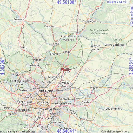
Plailly GPS coordinates[2]
49° 6' 10.368" North, 2° 35' 7.764" East
| Map corner | latitude | longitude |
|---|---|---|
| Upper-left | 49.56108°, | 1.88236° |
| Center: | 49.10288°, | 2.58549° |
| Lower-right: | 48.64041°, | 3.28861° |
| Map W x H: | 102.4×102.4 km | = 63.6×63.6mi |
| max Lat: | 51.07786° ⇑17.8% North |
| Plailly: | 49.10288° |
| min Lat: | ⇓82.2% South 41.3874° |
| min Long | Plailly | max Long |
| -5.08615° | 2.58549° | 9.52242° |
| W 51.9%⇐ | ⇒48.1% E |
Elevation
Elevation of Plailly is 106 m = 348 ft, and this is 87.7 m = 288 ft below average elevation for this country.
| Max E: |
2333 m = 7654 ft | 58.7% |
| Avg. | 193.7 m = 635 ft | |
| Plailly | 106 m = 348 ft | |
Min E: |
-1 m = -3 ft | 41.3% |
See also: France elevation on elevation.city.
Geographical zone
Plailly is located in North temperate zone (between Tropic of Cancer and the Arctic Circle). Distance of this North polar circle is 1941.4 km =1206.3 mi to North.| Distance of | km | miles | from Plailly |
|---|---|---|---|
| North Pole | 4547.3 | 2825.6 | to North |
| Arctic Circle | 1941.4 | 1206.3 | to North |
| Tropic Cancer | 2853.8 | 1773.3 | to South |
| Equator | 5459.7 | 3392.5 | to South |


Nearby cities:
15 places around Plailly: (largest is in red/bold)
• Fosses
5.6 km =3.5 mi,  264°
264°
• La Chapelle-en-Serval
4.7 km =2.9 mi,  307°
307°
• Marly-la-Ville
6.4 km =4 mi,  248°
248°
• Moussy-le-Neuf
4.5 km =2.8 mi,  163°
163°
• Moussy-le-Vieux
6.8 km =4.2 mi, 155°
• Orry-la-Ville
6.4 km =4 mi,  302°
302°
• Othis
7.3 km =4.5 mi,  116°
116°
• Pontarmé
6.2 km =3.9 mi,  335°
335°
• Puiseux-en-France
8.1 km =5 mi,  229°
229°
• Saint-Witz
1.7 km =1.1 mi,  218°
218°
• Survilliers
3.1 km =1.9 mi, 257°
• Thiers-sur-Thève
5.6 km =3.5 mi,  348°
348°
• Ver-sur-Launette
7.2 km =4.5 mi,  88°
88°
• Villeron
5.9 km =3.7 mi,  211°
211°
• Vémars
4 km =2.5 mi,  200°
200°
Sources, notices
• [Note1] Compared only with cities in France existing in our database
• [Src1] Map data: © OpenStreetMap contributors (CC-BY-SA)
• [Src2] Other city data from geonames.org with taken over terms of usage.
• [Src3] Geographical zone / Annual Mean Temperature by Robert A. Rohde @ Wikipedia
