Fosses geodata
Fosses (Île-de-France) is a populated place; located in France in Europe/Paris (GMT+2) time zone. With population of 10,543 people, there are 906 cities with bigger population in this country. Compared to other cities in France, 82.1% of cities are located further ↓South; 50.8% of cities are located further ←West and 54.8% of cities have higher elevation than Fosses. Note1
Administrative division(s):
- Level 1: Île-de-France
- Level 2: Département du Val-d’Oise
- Level 3: Arrondissement de Sarcelles
- Level 4: Fosses


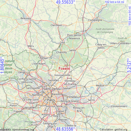
Fosses GPS coordinates[2]
49° 5' 53.088" North, 2° 30' 34.452" East
| Map corner | latitude | longitude |
|---|---|---|
| Upper-left | 49.55633°, | 1.80645° |
| Center: | 49.09808°, | 2.50957° |
| Lower-right: | 48.63556°, | 3.2127° |
| Map W x H: | 102.4×102.4 km | = 63.6×63.6mi |
| max Lat: | 51.07786° ⇑17.9% North |
| Fosses: | 49.09808° |
| min Lat: | ⇓82.1% South 41.3874° |
| min Long | Fosses | max Long |
| -5.08615° | 2.50957° | 9.52242° |
| W 50.8%⇐ | ⇒49.2% E |
Elevation
Elevation of Fosses is 117 m = 384 ft, and this is 76.7 m = 252 ft below average elevation for this country.
| Max E: |
2333 m = 7654 ft | 54.8% |
| Avg. | 193.7 m = 635 ft | |
| Fosses | 117 m = 384 ft | |
Min E: |
-1 m = -3 ft | 45.2% |
See also: France elevation on elevation.city.
Geographical zone
Fosses is located in North temperate zone (between Tropic of Cancer and the Arctic Circle). Distance of this North polar circle is 1942 km =1206.7 mi to North.| Distance of | km | miles | from Fosses |
|---|---|---|---|
| North Pole | 4547.9 | 2825.9 | to North |
| Arctic Circle | 1942 | 1206.7 | to North |
| Tropic Cancer | 2853.3 | 1773 | to South |
| Equator | 5459.2 | 3392.2 | to South |


Nearby cities:
15 places around Fosses: (largest is in red/bold)
• Bellefontaine
3.1 km =1.9 mi,  269°
269°
• Chaumontel
6.4 km =4 mi,  297°
297°
• Coye-la-Forêt
5.7 km =3.5 mi,  329°
329°
• Fontenay-en-Parisis
6.5 km =4 mi,  220°
220°
• La Chapelle-en-Serval
3.8 km =2.4 mi,  27°
27°
• Louvres
6 km =3.7 mi,  183°
183°
• Luzarches
6.6 km =4.1 mi,  284°
284°
• Marly-la-Ville
1.8 km =1.1 mi,  193°
193°
• Orry-la-Ville
3.9 km =2.4 mi,  1°
1°
• Plailly
5.6 km =3.5 mi,  84°
84°
• Puiseux-en-France
4.8 km =3 mi, 188°
• Saint-Witz
4.6 km =2.9 mi,  99°
99°
• Survilliers
2.5 km =1.6 mi,  92°
92°
• Villeron
5.1 km =3.2 mi,  151°
151°
• Vémars
5.2 km =3.2 mi,  127°
127°
Sources, notices
• [Note1] Compared only with cities in France existing in our database
• [Src1] Map data: © OpenStreetMap contributors (CC-BY-SA)
• [Src2] Other city data from geonames.org with taken over terms of usage.
• [Src3] Geographical zone / Annual Mean Temperature by Robert A. Rohde @ Wikipedia
