Strasbourg geodata
Strasbourg (Grand Est) is a seat of a first-order administrative division; located in France in Europe/Paris (GMT+2) time zone. With population of 274,845 people, there are 6 cities with bigger population in this country. Compared to other cities in France, 70.5% of cities are located further ↓South; 99.2% of cities are located further ←West and 54.2% of cities have lower elevation than Strasbourg. Note1
Administrative division(s):
- Level 1: Grand Est
- Level 2: Bas-Rhin
- Level 3: Arrondissement de Strasbourg
- Level 4: Strasbourg


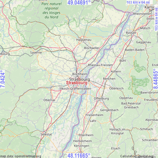
Strasbourg GPS coordinates[2]
48° 35' 2.112" North, 7° 44' 43.908" East
| Map corner | latitude | longitude |
|---|---|---|
| Upper-left | 49.04691°, | 7.0424° |
| Center: | 48.58392°, | 7.74553° |
| Lower-right: | 48.11665°, | 8.44865° |
| Map W x H: | 103.4×103.4 km | = 64.2×64.2mi |
| max Lat: | 51.07786° ⇑29.5% North |
| Strasbourg: | 48.58392° |
| min Lat: | ⇓70.5% South 41.3874° |
| min Long | Strasbourg | max Long |
| -5.08615° | 7.74553° | 9.52242° |
| W 99.2%⇐ | ⇒0.8% E |
Elevation
Elevation of Strasbourg is 147 m = 482 ft, and this is 46.7 m = 153 ft below average elevation for this country.
| Max E: |
2333 m = 7654 ft | 45.8% |
| Avg. | 193.7 m = 635 ft | |
| Strasbourg | 147 m = 482 ft | |
Min E: |
-1 m = -3 ft | 54.2% |
See also: Strasbourg elevation on elevation.city.
Geographical zone
Strasbourg is located in North temperate zone (between Tropic of Cancer and the Arctic Circle). Distance of this North polar circle is 1999.1 km =1242.2 mi to North.| Distance of | km | miles | from Strasbourg |
|---|---|---|---|
| North Pole | 4605 | 2861.4 | to North |
| Arctic Circle | 1999.1 | 1242.2 | to North |
| Tropic Cancer | 2796.1 | 1737.4 | to South |
| Equator | 5402 | 3356.6 | to South |


Nearby cities:
15 places around Strasbourg: (largest is in red/bold)
• Bischheim
3.6 km =2.2 mi,  9°
9°
• Eckbolsheim
4.3 km =2.7 mi,  265°
265°
• Hœnheim
4.3 km =2.7 mi, 9°
• Illkirch-Graffenstaden
6.5 km =4 mi,  200°
200°
• Lingolsheim
5.5 km =3.4 mi,  237°
237°
• Mittelhausbergen
5.3 km =3.3 mi,  309°
309°
• Mundolsheim
6.9 km =4.3 mi,  340°
340°
• Niederhausbergen
5.5 km =3.4 mi,  324°
324°
• Oberhausbergen
4.9 km =3 mi,  300°
300°
• Oberschaeffolsheim
7 km =4.3 mi, 272°
• Ostwald
5.1 km =3.2 mi,  209°
209°
• Reichstett
7.2 km =4.5 mi, 5°
• Schiltigheim
2.6 km =1.6 mi, 6°
• Souffelweyersheim
5.7 km =3.5 mi,  356°
356°
• Wolfisheim
5.8 km =3.6 mi, 273°
In other languages:
- In Spanish: Estrasburgo
- In German: Straßburg
- In Italian: Strasburgo
- In Russian: Страсбург
- In Chinese: 斯特拉斯堡
Sources, notices
• [Note1] Compared only with cities in France existing in our database
• [Src1] Map data: © OpenStreetMap contributors (CC-BY-SA)
• [Src2] Other city data from geonames.org with taken over terms of usage.
• [Src3] Geographical zone / Annual Mean Temperature by Robert A. Rohde @ Wikipedia
