Stains geodata
Stains (Île-de-France) is a populated place; located in France in Europe/Paris (GMT+2) time zone. With population of 32,601 people, there are 240 cities with bigger population in this country. Compared to other cities in France, 78.5% of cities are located further ↓South; 51.4% of cities are located further →East and 86.2% of cities have higher elevation than Stains. Note1
Administrative division(s):
- Level 1: Île-de-France
- Level 2: Seine-Saint-Denis
- Level 3: Arrondissement de Saint-Denis
- Level 4: Stains


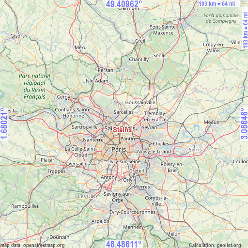
Stains GPS coordinates[2]
48° 57' 0" North, 2° 22' 59.988" East
| Map corner | latitude | longitude |
|---|---|---|
| Upper-left | 49.40962°, | 1.68021° |
| Center: | 48.95°, | 2.38333° |
| Lower-right: | 48.48611°, | 3.08646° |
| Map W x H: | 102.7×102.7 km | = 63.8×63.8mi |
| max Lat: | 51.07786° ⇑21.5% North |
| Stains: | 48.95° |
| min Lat: | ⇓78.5% South 41.3874° |
| min Long | Stains | max Long |
| -5.08615° | 2.38333° | 9.52242° |
| W 48.6%⇐ | ⇒51.4% E |
Elevation
Elevation of Stains is 39 m = 128 ft, and this is 154.7 m = 508 ft below average elevation for this country.
| Max E: |
2333 m = 7654 ft | 86.2% |
| Avg. | 193.7 m = 635 ft | |
| Stains | 39 m = 128 ft | |
Min E: |
-1 m = -3 ft | 13.8% |
See also: France elevation on elevation.city.
Geographical zone
Stains is located in North temperate zone (between Tropic of Cancer and the Arctic Circle). Distance of this North polar circle is 1958.4 km =1216.9 mi to North.| Distance of | km | miles | from Stains |
|---|---|---|---|
| North Pole | 4564.3 | 2836.1 | to North |
| Arctic Circle | 1958.4 | 1216.9 | to North |
| Tropic Cancer | 2836.8 | 1762.7 | to South |
| Equator | 5442.7 | 3381.9 | to South |


Nearby cities:
15 places around Stains: (largest is in red/bold)
• Arnouville
4.4 km =2.7 mi,  33°
33°
• Aubervilliers
3.7 km =2.3 mi,  180°
180°
• Bonneuil-en-France
4.4 km =2.7 mi,  52°
52°
• Deuil-la-Barre
5.1 km =3.2 mi,  305°
305°
• Dugny
2.5 km =1.6 mi,  80°
80°
• Garges-lès-Gonesse
2.3 km =1.4 mi, 27°
• Groslay
4.8 km =3 mi,  326°
326°
• La Courneuve
2.6 km =1.6 mi,  158°
158°
• Le Bourget
4.2 km =2.6 mi,  114°
114°
• Montmagny
3.7 km =2.3 mi, 314°
• Pierrefitte-sur-Seine
2.5 km =1.6 mi,  319°
319°
• Saint-Denis
2.7 km =1.7 mi,  233°
233°
• Villeneuve-la-Garenne
5.1 km =3.2 mi,  256°
256°
• Villetaneuse
3.2 km =2 mi,  286°
286°
• Épinay-sur-Seine
5 km =3.1 mi,  274°
274°
Sources, notices
• [Note1] Compared only with cities in France existing in our database
• [Src1] Map data: © OpenStreetMap contributors (CC-BY-SA)
• [Src2] Other city data from geonames.org with taken over terms of usage.
• [Src3] Geographical zone / Annual Mean Temperature by Robert A. Rohde @ Wikipedia
