Garges-lès-Gonesse geodata
Garges-lès-Gonesse (Île-de-France) is a populated place; located in France in Europe/Paris (GMT+2) time zone. With population of 39,847 people, there are 181 cities with bigger population in this country. Compared to other cities in France, 79% of cities are located further ↓South; 51.1% of cities are located further →East and 76.2% of cities have higher elevation than Garges-lès-Gonesse. Note1
Administrative division(s):
- Level 1: Île-de-France
- Level 2: Département du Val-d’Oise
- Level 3: Arrondissement de Sarcelles
- Level 4: Garges-lès-Gonesse


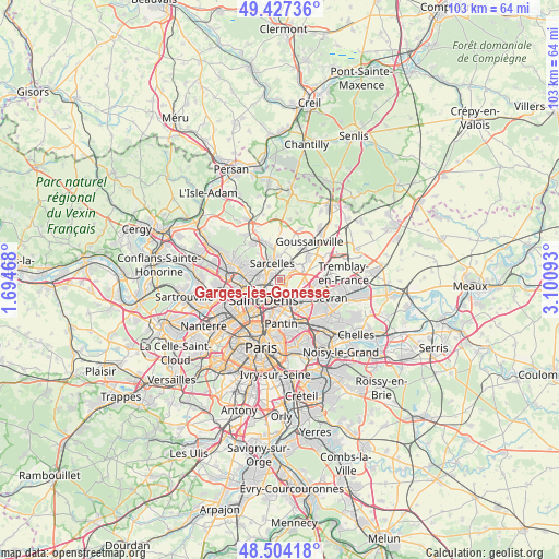
Garges-lès-Gonesse GPS coordinates[2]
48° 58' 4.476" North, 2° 23' 52.116" East
| Map corner | latitude | longitude |
|---|---|---|
| Upper-left | 49.42736°, | 1.69468° |
| Center: | 48.96791°, | 2.39781° |
| Lower-right: | 48.50418°, | 3.10093° |
| Map W x H: | 102.6×102.6 km | = 63.8×63.8mi |
| max Lat: | 51.07786° ⇑21% North |
| Garges-lès-Gonesse: | 48.96791° |
| min Lat: | ⇓79% South 41.3874° |
| min Long | Garges-lès-Gon | max Long |
| -5.08615° | 2.39781° | 9.52242° |
| W 48.9%⇐ | ⇒51.1% E |
Elevation
Elevation of Garges-lès-Gonesse is 64 m = 210 ft, and this is 129.7 m = 426 ft below average elevation for this country.
| Max E: |
2333 m = 7654 ft | 76.2% |
| Avg. | 193.7 m = 635 ft | |
| Garges-lès-Gonesse | 64 m = 210 ft | |
Min E: |
-1 m = -3 ft | 23.8% |
See also: France elevation on elevation.city.
Geographical zone
Garges-lès-Gonesse is located in North temperate zone (between Tropic of Cancer and the Arctic Circle). Distance of this North polar circle is 1956.5 km =1215.7 mi to North.| Distance of | km | miles | from Garges-lès-Gonesse |
|---|---|---|---|
| North Pole | 4562.3 | 2834.9 | to North |
| Arctic Circle | 1956.5 | 1215.7 | to North |
| Tropic Cancer | 2838.8 | 1763.9 | to South |
| Equator | 5444.7 | 3383.2 | to South |


Nearby cities:
15 places around Garges-lès-Gonesse: (largest is in red/bold)
• Arnouville
2.2 km =1.4 mi,  38°
38°
• Bonneuil-en-France
2.6 km =1.6 mi,  73°
73°
• Dugny
2.1 km =1.3 mi,  137°
137°
• Gonesse
4.3 km =2.7 mi,  60°
60°
• Groslay
4.2 km =2.6 mi,  298°
298°
• La Courneuve
4.4 km =2.7 mi,  181°
181°
• Le Bourget
4.7 km =2.9 mi, 143°
• Montmagny
3.8 km =2.4 mi,  279°
279°
• Montmorency
4.6 km =2.9 mi, 299°
• Pierrefitte-sur-Seine
2.7 km =1.7 mi,  267°
267°
• Saint-Denis
4.8 km =3 mi,  221°
221°
• Sarcelles
3.6 km =2.2 mi,  336°
336°
• Stains
2.3 km =1.4 mi,  207°
207°
• Villetaneuse
4.2 km =2.6 mi,  255°
255°
• Villiers-le-Bel
4.5 km =2.8 mi,  0°
0°
Sources, notices
• [Note1] Compared only with cities in France existing in our database
• [Src1] Map data: © OpenStreetMap contributors (CC-BY-SA)
• [Src2] Other city data from geonames.org with taken over terms of usage.
• [Src3] Geographical zone / Annual Mean Temperature by Robert A. Rohde @ Wikipedia
