Schœneck geodata
Schœneck (Grand Est) is a populated place; located in France in Europe/Paris (GMT+2) time zone. With population of 2,846 people, there are 3427 cities with bigger population in this country. Compared to other cities in France, 84.6% of cities are located further ↓South; 94.4% of cities are located further ←West and 72.5% of cities have lower elevation than Schœneck. Note1
Administrative division(s):
- Level 1: Grand Est
- Level 2: Moselle
- Level 3: Arrondissement de Forbach-Boulay-Moselle
- Level 4: Schœneck


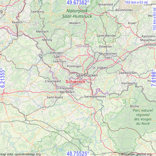
Schœneck GPS coordinates[2]
49° 13' 0.012" North, 6° 55' 0.012" East
| Map corner | latitude | longitude |
|---|---|---|
| Upper-left | 49.67382°, | 6.21355° |
| Center: | 49.21667°, | 6.91667° |
| Lower-right: | 48.75525°, | 7.6198° |
| Map W x H: | 102.1×102.1 km | = 63.4×63.4mi |
| max Lat: | 51.07786° ⇑15.4% North |
| Schœneck: | 49.21667° |
| min Lat: | ⇓84.6% South 41.3874° |
| min Long | Schœneck | max Long |
| -5.08615° | 6.91667° | 9.52242° |
| W 94.4%⇐ | ⇒5.6% E |
Elevation
Elevation of Schœneck is 233 m = 764 ft, and this is 39.3 m = 129 ft above average elevation for this country.
| Max E: |
2333 m = 7654 ft | 27.5% |
| Schœneck | 233 m 764 ft | |
| Avg. | 193.7 m = 635 ft | |
Min E: |
-1 m = -3 ft | 72.5% |
See also: France elevation on elevation.city.
Geographical zone
Schœneck is located in North temperate zone (between Tropic of Cancer and the Arctic Circle). Distance of this North polar circle is 1928.8 km =1198.5 mi to North.| Distance of | km | miles | from Schœneck |
|---|---|---|---|
| North Pole | 4534.7 | 2817.7 | to North |
| Arctic Circle | 1928.8 | 1198.5 | to North |
| Tropic Cancer | 2866.5 | 1781.2 | to South |
| Equator | 5472.4 | 3400.4 | to South |


Nearby cities:
15 places around Schœneck: (largest is in red/bold)
• Alsting
6.7 km =4.2 mi,  125°
125°
• Behren-lès-Forbach
5.5 km =3.4 mi,  162°
162°
• Bousbach
7.9 km =4.9 mi, 161°
• Cocheren
9.2 km =5.7 mi,  208°
208°
• Etzling
5.1 km =3.2 mi,  143°
143°
• Folkling
7.8 km =4.8 mi,  191°
191°
• Forbach
3.6 km =2.2 mi, 209°
• Kerbach
6.6 km =4.1 mi,  147°
147°
• Lixing-lès-Rouhling
9 km =5.6 mi, 141°
• Morsbach
6.3 km =3.9 mi, 211°
• Petite-Rosselle
4.4 km =2.7 mi,  262°
262°
• Rosbruck
8.1 km =5 mi,  216°
216°
• Spicheren
4.5 km =2.8 mi, 126°
• Stiring-Wendel
2 km =1.2 mi, 146°
• Œting
4.9 km =3 mi,  181°
181°
Sources, notices
• [Note1] Compared only with cities in France existing in our database
• [Src1] Map data: © OpenStreetMap contributors (CC-BY-SA)
• [Src2] Other city data from geonames.org with taken over terms of usage.
• [Src3] Geographical zone / Annual Mean Temperature by Robert A. Rohde @ Wikipedia
