Souvigné geodata
Souvigné (Centre) is a populated place; located in France in Europe/Paris (GMT+2) time zone. With population of 580 people, there are 13652 cities with bigger population in this country. Compared to other cities in France, 51.5% of cities are located further ↓South; 74.4% of cities are located further →East and 65.3% of cities have higher elevation than Souvigné. Note1
Administrative division(s):
- Level 1: Centre
- Level 2: Département d'Indre-et-Loire
- Level 3: Arrondissement de Chinon
- Level 4: Souvigné


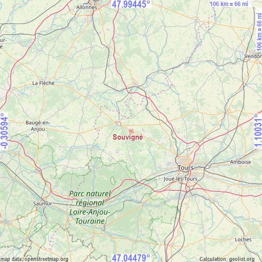
Souvigné GPS coordinates[2]
47° 31' 18.372" North, 0° 23' 49.884" East
| Map corner | latitude | longitude |
|---|---|---|
| Upper-left | 47.99445°, | -0.30594° |
| Center: | 47.52177°, | 0.39719° |
| Lower-right: | 47.04479°, | 1.10031° |
| Map W x H: | 105.6×105.6 km | = 65.6×65.6mi |
| max Lat: | 51.07786° ⇑48.5% North |
| Souvigné: | 47.52177° |
| min Lat: | ⇓51.5% South 41.3874° |
| min Long | Souvigné | max Long |
| -5.08615° | 0.39719° | 9.52242° |
| W 25.6%⇐ | ⇒74.4% E |
Elevation
Elevation of Souvigné is 89 m = 292 ft, and this is 104.7 m = 344 ft below average elevation for this country.
| Max E: |
2333 m = 7654 ft | 65.3% |
| Avg. | 193.7 m = 635 ft | |
| Souvigné | 89 m = 292 ft | |
Min E: |
-1 m = -3 ft | 34.7% |
See also: France elevation on elevation.city.
Geographical zone
Souvigné is located in North temperate zone (between Tropic of Cancer and the Arctic Circle). Distance of this North polar circle is 2117.2 km =1315.6 mi to North.| Distance of | km | miles | from Souvigné |
|---|---|---|---|
| North Pole | 4723.1 | 2934.8 | to North |
| Arctic Circle | 2117.2 | 1315.6 | to North |
| Tropic Cancer | 2678 | 1664 | to South |
| Equator | 5283.9 | 3283.3 | to South |


Nearby cities:
15 places around Souvigné: (largest is in red/bold)
• Ambillou
8.7 km =5.4 mi,  154°
154°
• Channay-sur-Lathan
11.1 km =6.9 mi,  244°
244°
• Château-la-Vallière
6.1 km =3.8 mi,  296°
296°
• Cléré-les-Pins
10.7 km =6.6 mi,  183°
183°
• Couesmes
6.3 km =3.9 mi,  318°
318°
• Hommes
13.1 km =8.1 mi,  215°
215°
• Mazières-de-Touraine
15.5 km =9.6 mi,  172°
172°
• Neuillé-Pont-Pierre
11.8 km =7.3 mi,  75°
75°
• Pernay
11.7 km =7.3 mi,  138°
138°
• Saint-Christophe-sur-le-Nais
12.2 km =7.6 mi,  29°
29°
• Saint-Paterne-Racan
11.1 km =6.9 mi,  36°
36°
• Savigné-sur-Lathan
10.3 km =6.4 mi,  213°
213°
• Semblançay
14.2 km =8.8 mi,  99°
99°
• Sonzay
4.9 km =3 mi, 83°
• Villiers-au-Bouin
8.6 km =5.3 mi,  312°
312°
Sources, notices
• [Note1] Compared only with cities in France existing in our database
• [Src1] Map data: © OpenStreetMap contributors (CC-BY-SA)
• [Src2] Other city data from geonames.org with taken over terms of usage.
• [Src3] Geographical zone / Annual Mean Temperature by Robert A. Rohde @ Wikipedia
