Ambillou geodata
Ambillou (Centre) is a populated place; located in France in Europe/Paris (GMT+2) time zone. With population of 1,359 people, there are 6771 cities with bigger population in this country. Compared to other cities in France, 50.5% of cities are located further ↓South; 73.9% of cities are located further →East and 60.8% of cities have higher elevation than Ambillou. Note1
Administrative division(s):
- Level 1: Centre
- Level 2: Département d'Indre-et-Loire
- Level 3: Arrondissement de Chinon
- Level 4: Ambillou


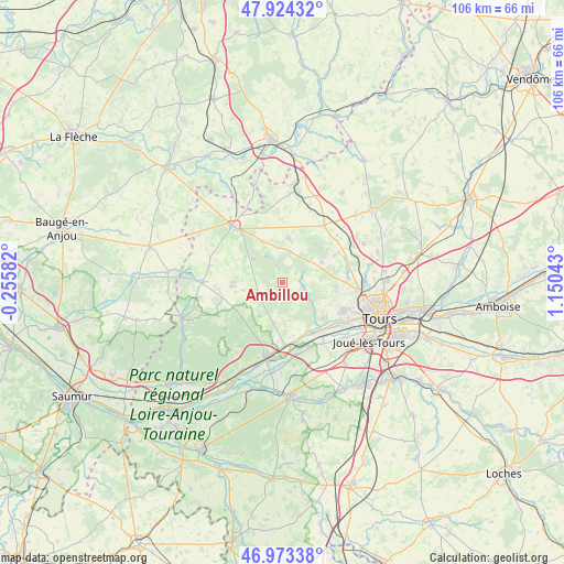
Ambillou GPS coordinates[2]
47° 27' 3.6" North, 0° 26' 50.28" East
| Map corner | latitude | longitude |
|---|---|---|
| Upper-left | 47.92432°, | -0.25582° |
| Center: | 47.451°, | 0.4473° |
| Lower-right: | 46.97338°, | 1.15043° |
| Map W x H: | 105.7×105.7 km | = 65.7×65.7mi |
| max Lat: | 51.07786° ⇑49.5% North |
| Ambillou: | 47.451° |
| min Lat: | ⇓50.5% South 41.3874° |
| min Long | Ambillou | max Long |
| -5.08615° | 0.4473° | 9.52242° |
| W 26.1%⇐ | ⇒73.9% E |
Elevation
Elevation of Ambillou is 100 m = 328 ft, and this is 93.7 m = 307 ft below average elevation for this country.
| Max E: |
2333 m = 7654 ft | 60.8% |
| Avg. | 193.7 m = 635 ft | |
| Ambillou | 100 m = 328 ft | |
Min E: |
-1 m = -3 ft | 39.2% |
See also: France elevation on elevation.city.
Geographical zone
Ambillou is located in North temperate zone (between Tropic of Cancer and the Arctic Circle). Distance of this North polar circle is 2125.1 km =1320.5 mi to North.| Distance of | km | miles | from Ambillou |
|---|---|---|---|
| North Pole | 4731 | 2939.7 | to North |
| Arctic Circle | 2125.1 | 1320.5 | to North |
| Tropic Cancer | 2670.1 | 1659.1 | to South |
| Equator | 5276.1 | 3278.4 | to South |


Nearby cities:
15 places around Ambillou: (largest is in red/bold)
• Berthenay
11.4 km =7.1 mi,  148°
148°
• Charentilly
12.3 km =7.6 mi,  80°
80°
• Cinq-Mars-la-Pile
11.7 km =7.3 mi,  175°
175°
• Cléré-les-Pins
5.2 km =3.2 mi,  236°
236°
• Fondettes
12.4 km =7.7 mi,  115°
115°
• Hommes
11.7 km =7.3 mi,  256°
256°
• Luynes
11 km =6.8 mi,  132°
132°
• Mazières-de-Touraine
7.7 km =4.8 mi,  192°
192°
• Pernay
4.1 km =2.5 mi,  102°
102°
• Saint-Roch
10.4 km =6.5 mi, 95°
• Saint-Étienne-de-Chigny
9.9 km =6.2 mi,  139°
139°
• Savigné-sur-Lathan
9.5 km =5.9 mi,  265°
265°
• Semblançay
11.6 km =7.2 mi,  61°
61°
• Sonzay
8.5 km =5.3 mi,  7°
7°
• Souvigné
8.7 km =5.4 mi,  334°
334°
Sources, notices
• [Note1] Compared only with cities in France existing in our database
• [Src1] Map data: © OpenStreetMap contributors (CC-BY-SA)
• [Src2] Other city data from geonames.org with taken over terms of usage.
• [Src3] Geographical zone / Annual Mean Temperature by Robert A. Rohde @ Wikipedia
