Château-la-Vallière geodata
Château-la-Vallière (Centre) is a populated place; located in France in Europe/Paris (GMT+2) time zone. With population of 1,615 people, there are 5780 cities with bigger population in this country. Compared to other cities in France, 51.9% of cities are located further ↓South; 75.1% of cities are located further →East and 62% of cities have higher elevation than Château-la-Vallière. Note1
Administrative division(s):
- Level 1: Centre
- Level 2: Département d'Indre-et-Loire
- Level 3: Arrondissement de Chinon
- Level 4: Château-la-Vallière


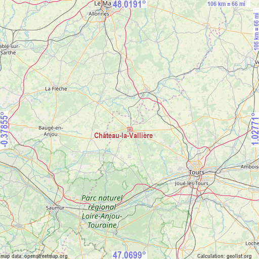
Château-la-Vallière GPS coordinates[2]
47° 32' 47.94" North, 0° 19' 28.488" East
| Map corner | latitude | longitude |
|---|---|---|
| Upper-left | 48.0191°, | -0.37855° |
| Center: | 47.54665°, | 0.32458° |
| Lower-right: | 47.0699°, | 1.02771° |
| Map W x H: | 105.5×105.5 km | = 65.6×65.6mi |
| max Lat: | 51.07786° ⇑48.1% North |
| Château-la-Vallière: | 47.54665° |
| min Lat: | ⇓51.9% South 41.3874° |
| min Long | Château-la-Val | max Long |
| -5.08615° | 0.32458° | 9.52242° |
| W 24.9%⇐ | ⇒75.1% E |
Elevation
Elevation of Château-la-Vallière is 97 m = 318 ft, and this is 96.7 m = 317 ft below average elevation for this country.
| Max E: |
2333 m = 7654 ft | 62% |
| Avg. | 193.7 m = 635 ft | |
| Château-la-Vallière | 97 m = 318 ft | |
Min E: |
-1 m = -3 ft | 38% |
See also: France elevation on elevation.city.
Geographical zone
Château-la-Vallière is located in North temperate zone (between Tropic of Cancer and the Arctic Circle). Distance of this North polar circle is 2114.5 km =1313.9 mi to North.| Distance of | km | miles | from Château-la-Vallière |
|---|---|---|---|
| North Pole | 4720.4 | 2933.1 | to North |
| Arctic Circle | 2114.5 | 1313.9 | to North |
| Tropic Cancer | 2680.8 | 1665.8 | to South |
| Equator | 5286.7 | 3285 | to South |


Nearby cities:
15 places around Château-la-Vallière: (largest is in red/bold)
• Ambillou
14.1 km =8.8 mi,  139°
139°
• Channay-sur-Lathan
8.8 km =5.5 mi,  211°
211°
• Cléré-les-Pins
14.3 km =8.9 mi,  160°
160°
• Couesmes
2.3 km =1.4 mi,  33°
33°
• Dissé-sous-le-Lude
14.5 km =9 mi,  298°
298°
• Hommes
13.6 km =8.5 mi,  189°
189°
• Montabon
15.8 km =9.8 mi,  16°
16°
• Noyant
16 km =9.9 mi,  255°
255°
• Saint-Christophe-sur-le-Nais
13.9 km =8.6 mi,  55°
55°
• Saint-Paterne-Racan
13.5 km =8.4 mi, 62°
• Savigné-sur-Lathan
11.3 km =7 mi,  181°
181°
• Sonzay
10.5 km =6.5 mi,  102°
102°
• Souvigné
6.1 km =3.8 mi,  116°
116°
• Vaas
13.6 km =8.5 mi,  357°
357°
• Villiers-au-Bouin
3.2 km =2 mi,  344°
344°
Sources, notices
• [Note1] Compared only with cities in France existing in our database
• [Src1] Map data: © OpenStreetMap contributors (CC-BY-SA)
• [Src2] Other city data from geonames.org with taken over terms of usage.
• [Src3] Geographical zone / Annual Mean Temperature by Robert A. Rohde @ Wikipedia
