Sours geodata
Sours (Centre) is a populated place; located in France in Europe/Paris (GMT+2) time zone. With population of 2,071 people, there are 4638 cities with bigger population in this country. Compared to other cities in France, 66.5% of cities are located further ↓South; 61.8% of cities are located further →East and 55.3% of cities have lower elevation than Sours. Note1
Administrative division(s):
- Level 1: Centre
- Level 2: Département d'Eure-et-Loir
- Level 3: Arrondissement de Chartres
- Level 4: Sours


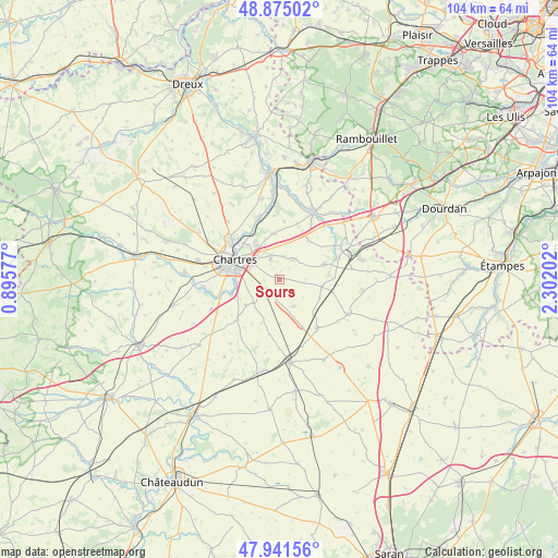
Sours GPS coordinates[2]
48° 24' 37.548" North, 1° 35' 56.004" East
| Map corner | latitude | longitude |
|---|---|---|
| Upper-left | 48.87502°, | 0.89577° |
| Center: | 48.41043°, | 1.59889° |
| Lower-right: | 47.94156°, | 2.30202° |
| Map W x H: | 103.8×103.8 km | = 64.5×64.5mi |
| max Lat: | 51.07786° ⇑33.5% North |
| Sours: | 48.41043° |
| min Lat: | ⇓66.5% South 41.3874° |
| min Long | Sours | max Long |
| -5.08615° | 1.59889° | 9.52242° |
| W 38.2%⇐ | ⇒61.8% E |
Elevation
Elevation of Sours is 151 m = 495 ft, and this is 42.7 m = 140 ft below average elevation for this country.
| Max E: |
2333 m = 7654 ft | 44.7% |
| Avg. | 193.7 m = 635 ft | |
| Sours | 151 m = 495 ft | |
Min E: |
-1 m = -3 ft | 55.3% |
See also: France elevation on elevation.city.
Geographical zone
Sours is located in North temperate zone (between Tropic of Cancer and the Arctic Circle). Distance of this North polar circle is 2018.4 km =1254.2 mi to North.| Distance of | km | miles | from Sours |
|---|---|---|---|
| North Pole | 4624.3 | 2873.4 | to North |
| Arctic Circle | 2018.4 | 1254.2 | to North |
| Tropic Cancer | 2776.8 | 1725.4 | to South |
| Equator | 5382.7 | 3344.7 | to South |


Nearby cities:
15 places around Sours: (largest is in red/bold)
• Barjouville
9 km =5.6 mi,  269°
269°
• Berchères-les-Pierres
4.3 km =2.7 mi,  229°
229°
• Béville-le-Comte
8.9 km =5.5 mi,  71°
71°
• Champhol
9.6 km =6 mi,  312°
312°
• Chartres
9 km =5.6 mi,  296°
296°
• Coltainville
8.6 km =5.3 mi,  354°
354°
• Francourville
4.5 km =2.8 mi,  96°
96°
• Gasville-Oisème
8 km =5 mi,  325°
325°
• Le Coudray
7.4 km =4.6 mi,  279°
279°
• Lucé
10.4 km =6.5 mi,  286°
286°
• Luisant
9.5 km =5.9 mi, 282°
• Morancez
7.8 km =4.8 mi,  261°
261°
• Nogent-le-Phaye
4.2 km =2.6 mi,  338°
338°
• Prunay-le-Gillon
5.8 km =3.6 mi,  152°
152°
• Saint-Prest
10.3 km =6.4 mi, 330°
Sources, notices
• [Note1] Compared only with cities in France existing in our database
• [Src1] Map data: © OpenStreetMap contributors (CC-BY-SA)
• [Src2] Other city data from geonames.org with taken over terms of usage.
• [Src3] Geographical zone / Annual Mean Temperature by Robert A. Rohde @ Wikipedia
