Morancez geodata
Morancez (Centre) is a populated place; located in France in Europe/Paris (GMT+2) time zone. With population of 1,687 people, there are 5554 cities with bigger population in this country. Compared to other cities in France, 66.4% of cities are located further ↓South; 63.1% of cities are located further →East and 51.4% of cities have lower elevation than Morancez. Note1
Administrative division(s):
- Level 1: Centre
- Level 2: Département d'Eure-et-Loir
- Level 3: Arrondissement de Chartres
- Level 4: Morancez


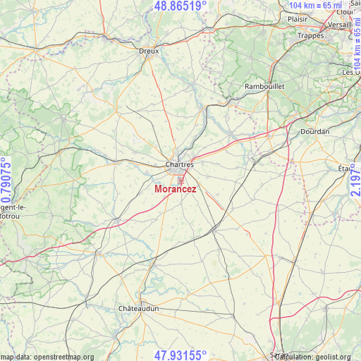
Morancez GPS coordinates[2]
48° 24' 1.836" North, 1° 29' 37.968" East
| Map corner | latitude | longitude |
|---|---|---|
| Upper-left | 48.86519°, | 0.79075° |
| Center: | 48.40051°, | 1.49388° |
| Lower-right: | 47.93155°, | 2.197° |
| Map W x H: | 103.8×103.8 km | = 64.5×64.5mi |
| max Lat: | 51.07786° ⇑33.6% North |
| Morancez: | 48.40051° |
| min Lat: | ⇓66.4% South 41.3874° |
| min Long | Morancez | max Long |
| -5.08615° | 1.49388° | 9.52242° |
| W 36.9%⇐ | ⇒63.1% E |
Elevation
Elevation of Morancez is 137 m = 449 ft, and this is 56.7 m = 186 ft below average elevation for this country.
| Max E: |
2333 m = 7654 ft | 48.6% |
| Avg. | 193.7 m = 635 ft | |
| Morancez | 137 m = 449 ft | |
Min E: |
-1 m = -3 ft | 51.4% |
See also: France elevation on elevation.city.
Geographical zone
Morancez is located in North temperate zone (between Tropic of Cancer and the Arctic Circle). Distance of this North polar circle is 2019.5 km =1254.9 mi to North.| Distance of | km | miles | from Morancez |
|---|---|---|---|
| North Pole | 4625.4 | 2874.1 | to North |
| Arctic Circle | 2019.5 | 1254.9 | to North |
| Tropic Cancer | 2775.7 | 1724.7 | to South |
| Equator | 5381.6 | 3344 | to South |


Nearby cities:
15 places around Morancez: (largest is in red/bold)
• Barjouville
1.7 km =1.1 mi,  309°
309°
• Berchères-les-Pierres
4.8 km =3 mi,  110°
110°
• Champhol
7.5 km =4.7 mi,  5°
5°
• Chartres
5.2 km =3.2 mi,  356°
356°
• Dammarie
6.4 km =4 mi,  179°
179°
• Fontenay-sur-Eure
6.1 km =3.8 mi,  264°
264°
• Le Coudray
2.3 km =1.4 mi, 12°
• Lucé
4.6 km =2.9 mi,  331°
331°
• Luisant
3.5 km =2.2 mi,  335°
335°
• Lèves
7.8 km =4.8 mi,  353°
353°
• Mainvilliers
6.2 km =3.9 mi, 333°
• Mignières
6.8 km =4.2 mi,  227°
227°
• Nogent-le-Phaye
7.9 km =4.9 mi,  51°
51°
• Sours
7.8 km =4.8 mi,  81°
81°
• Thivars
4 km =2.5 mi, 231°
Sources, notices
• [Note1] Compared only with cities in France existing in our database
• [Src1] Map data: © OpenStreetMap contributors (CC-BY-SA)
• [Src2] Other city data from geonames.org with taken over terms of usage.
• [Src3] Geographical zone / Annual Mean Temperature by Robert A. Rohde @ Wikipedia
