Champhol geodata
Champhol (Centre) is a populated place; located in France in Europe/Paris (GMT+2) time zone. With population of 3,091 people, there are 3157 cities with bigger population in this country. Compared to other cities in France, 67.6% of cities are located further ↓South; 63% of cities are located further →East and 55.6% of cities have lower elevation than Champhol. Note1
Administrative division(s):
- Level 1: Centre
- Level 2: Département d'Eure-et-Loir
- Level 3: Arrondissement de Chartres
- Level 4: Champhol


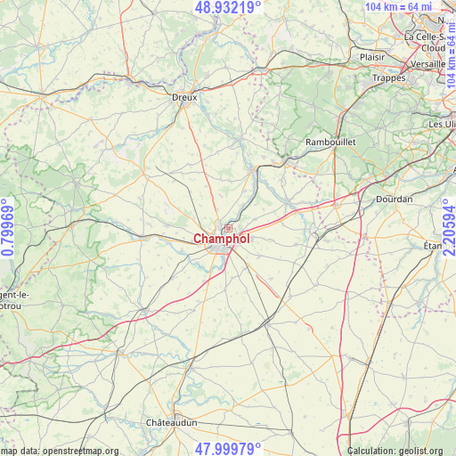
Champhol GPS coordinates[2]
48° 28' 5.268" North, 1° 30' 10.116" East
| Map corner | latitude | longitude |
|---|---|---|
| Upper-left | 48.93219°, | 0.79969° |
| Center: | 48.46813°, | 1.50281° |
| Lower-right: | 47.99979°, | 2.20594° |
| Map W x H: | 103.7×103.7 km | = 64.4×64.4mi |
| max Lat: | 51.07786° ⇑32.4% North |
| Champhol: | 48.46813° |
| min Lat: | ⇓67.6% South 41.3874° |
| min Long | Champhol | max Long |
| -5.08615° | 1.50281° | 9.52242° |
| W 37%⇐ | ⇒63% E |
Elevation
Elevation of Champhol is 152 m = 499 ft, and this is 41.7 m = 137 ft below average elevation for this country.
| Max E: |
2333 m = 7654 ft | 44.4% |
| Avg. | 193.7 m = 635 ft | |
| Champhol | 152 m = 499 ft | |
Min E: |
-1 m = -3 ft | 55.6% |
See also: France elevation on elevation.city.
Geographical zone
Champhol is located in North temperate zone (between Tropic of Cancer and the Arctic Circle). Distance of this North polar circle is 2012 km =1250.2 mi to North.| Distance of | km | miles | from Champhol |
|---|---|---|---|
| North Pole | 4617.9 | 2869.4 | to North |
| Arctic Circle | 2012 | 1250.2 | to North |
| Tropic Cancer | 2783.2 | 1729.4 | to South |
| Equator | 5389.2 | 3348.7 | to South |


Nearby cities:
15 places around Champhol: (largest is in red/bold)
• Amilly
8.5 km =5.3 mi,  251°
251°
• Bailleau-l’Évêque
8.2 km =5.1 mi,  286°
286°
• Barjouville
6.7 km =4.2 mi,  196°
196°
• Chartres
2.6 km =1.6 mi, 202°
• Coltainville
6.6 km =4.1 mi,  71°
71°
• Gasville-Oisème
2.6 km =1.6 mi,  86°
86°
• Jouy
5.6 km =3.5 mi,  33°
33°
• Le Coudray
5.2 km =3.2 mi,  181°
181°
• Lucé
4.5 km =2.8 mi,  219°
219°
• Luisant
4.8 km =3 mi,  206°
206°
• Lèves
1.6 km =1 mi,  280°
280°
• Mainvilliers
4 km =2.5 mi,  239°
239°
• Morancez
7.5 km =4.7 mi,  185°
185°
• Nogent-le-Phaye
6.1 km =3.8 mi,  114°
114°
• Saint-Prest
3.3 km =2.1 mi,  38°
38°
Sources, notices
• [Note1] Compared only with cities in France existing in our database
• [Src1] Map data: © OpenStreetMap contributors (CC-BY-SA)
• [Src2] Other city data from geonames.org with taken over terms of usage.
• [Src3] Geographical zone / Annual Mean Temperature by Robert A. Rohde @ Wikipedia
