Le Revest-les-Eaux geodata
Le Revest-les-Eaux (Provence-Alpes-Côte d'Azur) is a populated place; located in France in Europe/Paris (GMT+2) time zone. With population of 3,733 people, there are 2635 cities with bigger population in this country. Compared to other cities in France, 97.4% of cities are located further ↑North; 86.2% of cities are located further ←West and 66.4% of cities have lower elevation than Le Revest-les-Eaux. Note1
Administrative division(s):
- Level 1: Provence-Alpes-Côte d'Azur
- Level 2: Var
- Level 3: Arrondissement de Toulon
- Level 4: Le Revest-les-Eaux


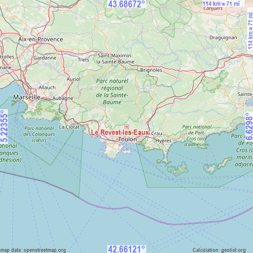
Le Revest-les-Eaux GPS coordinates[2]
43° 10' 34.032" North, 5° 55' 36.012" East
| Map corner | latitude | longitude |
|---|---|---|
| Upper-left | 43.68672°, | 5.22355° |
| Center: | 43.17612°, | 5.92667° |
| Lower-right: | 42.66121°, | 6.6298° |
| Map W x H: | 114×114 km | = 70.8×70.8mi |
| max Lat: | 51.07786° ⇑97.4% North |
| Le Revest-les-Eaux: | 43.17612° |
| min Lat: | ⇓2.6% South 41.3874° |
| min Long | Le Revest-les-E | max Long |
| -5.08615° | 5.92667° | 9.52242° |
| W 86.2%⇐ | ⇒13.8% E |
Elevation
Elevation of Le Revest-les-Eaux is 201 m = 659 ft, and this is 7.3 m = 24 ft above average elevation for this country.
| Max E: |
2333 m = 7654 ft | 33.6% |
| Le Revest-les-Eaux | 201 m 659 ft | |
| Avg. | 193.7 m = 635 ft | |
Min E: |
-1 m = -3 ft | 66.4% |
See also: France elevation on elevation.city.
Geographical zone
Le Revest-les-Eaux is located in North temperate zone (between Tropic of Cancer and the Arctic Circle). Distance of this Northern Tropic circle is 2194.8 km =1363.8 mi to South.| Distance of | km | miles | from Le Revest-les-Eaux |
|---|---|---|---|
| North Pole | 5206.3 | 3235 | to North |
| Arctic Circle | 2600.4 | 1615.8 | to North |
| Tropic Cancer | 2194.8 | 1363.8 | to South |
| Equator | 4800.7 | 2983 | to South |


Nearby cities:
15 places around Le Revest-les-Eaux: (largest is in red/bold)
• Belgentier
9.7 km =6 mi,  37°
37°
• La Farlède
9.5 km =5.9 mi,  95°
95°
• La Garde
8.9 km =5.5 mi,  130°
130°
• La Seyne-sur-Mer
9 km =5.6 mi,  205°
205°
• La Valette-du-Var
6.3 km =3.9 mi, 133°
• Le Beausset
10.3 km =6.4 mi,  283°
283°
• Le Pradet
11.1 km =6.9 mi,  135°
135°
• Ollioules
7.6 km =4.7 mi,  237°
237°
• Saint-Mandrier-sur-Mer
10.9 km =6.8 mi,  179°
179°
• Sanary-sur-Mer
11.9 km =7.4 mi, 238°
• Solliès-Pont
9.4 km =5.8 mi,  80°
80°
• Solliès-Toucas
8.6 km =5.3 mi,  67°
67°
• Solliès-Ville
9.1 km =5.7 mi,  85°
85°
• Toulon
5.8 km =3.6 mi, 178°
• Évenos
6.7 km =4.2 mi,  257°
257°
Sources, notices
• [Note1] Compared only with cities in France existing in our database
• [Src1] Map data: © OpenStreetMap contributors (CC-BY-SA)
• [Src2] Other city data from geonames.org with taken over terms of usage.
• [Src3] Geographical zone / Annual Mean Temperature by Robert A. Rohde @ Wikipedia
