Simandre geodata
Simandre (Bourgogne-Franche-Comté) is a populated place; located in France in Europe/Paris (GMT+2) time zone. With population of 1,285 people, there are 7101 cities with bigger population in this country. Compared to other cities in France, 59% of cities are located further ↑North; 77.5% of cities are located further ←West and 67.4% of cities have lower elevation than Simandre. Note1
Administrative division(s):
- Level 1: Bourgogne-Franche-Comté
- Level 2: Département de Saône-et-Loire
- Level 3: Arrondissement de Louhans
- Level 4: Simandre


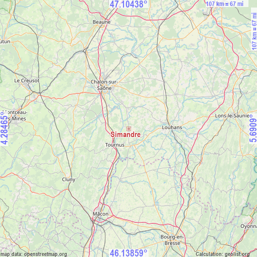
Simandre GPS coordinates[2]
46° 37' 25.104" North, 4° 59' 15.972" East
| Map corner | latitude | longitude |
|---|---|---|
| Upper-left | 47.10438°, | 4.28465° |
| Center: | 46.62364°, | 4.98777° |
| Lower-right: | 46.13859°, | 5.6909° |
| Map W x H: | 107.4×107.4 km | = 66.7×66.7mi |
| max Lat: | 51.07786° ⇑59% North |
| Simandre: | 46.62364° |
| min Lat: | ⇓41% South 41.3874° |
| min Long | Simandre | max Long |
| -5.08615° | 4.98777° | 9.52242° |
| W 77.5%⇐ | ⇒22.5% E |
Elevation
Elevation of Simandre is 206 m = 676 ft, and this is 12.3 m = 40 ft above average elevation for this country.
| Max E: |
2333 m = 7654 ft | 32.6% |
| Simandre | 206 m 676 ft | |
| Avg. | 193.7 m = 635 ft | |
Min E: |
-1 m = -3 ft | 67.4% |
See also: France elevation on elevation.city.
Geographical zone
Simandre is located in North temperate zone (between Tropic of Cancer and the Arctic Circle). Distance of this North polar circle is 2217.1 km =1377.6 mi to North.| Distance of | km | miles | from Simandre |
|---|---|---|---|
| North Pole | 4823 | 2996.9 | to North |
| Arctic Circle | 2217.1 | 1377.6 | to North |
| Tropic Cancer | 2578.1 | 1602 | to South |
| Equator | 5184.1 | 3221.2 | to South |


Nearby cities:
15 places around Simandre: (largest is in red/bold)
• Baudrières
5.8 km =3.6 mi,  18°
18°
• Boyer
8.7 km =5.4 mi,  246°
246°
• Cuisery
7.5 km =4.7 mi,  173°
173°
• Gigny-sur-Saône
5.4 km =3.4 mi,  322°
322°
• Lacrost
8.4 km =5.2 mi,  210°
210°
• Laives
11.2 km =7 mi,  281°
281°
• Loisy
5.6 km =3.5 mi,  147°
147°
• Ouroux-sur-Saône
11.2 km =7 mi,  346°
346°
• Préty
9.6 km =6 mi,  201°
201°
• Rancy
8.5 km =5.3 mi,  110°
110°
• Saint-Cyr
9.9 km =6.2 mi,  311°
311°
• Saint-Germain-du-Plain
8.4 km =5.2 mi,  358°
358°
• Saint-Étienne-en-Bresse
10.4 km =6.5 mi,  27°
27°
• Sennecey-le-Grand
9.4 km =5.8 mi, 282°
• Tournus
8.8 km =5.5 mi,  225°
225°
Sources, notices
• [Note1] Compared only with cities in France existing in our database
• [Src1] Map data: © OpenStreetMap contributors (CC-BY-SA)
• [Src2] Other city data from geonames.org with taken over terms of usage.
• [Src3] Geographical zone / Annual Mean Temperature by Robert A. Rohde @ Wikipedia
