Boyer geodata
Boyer (Bourgogne-Franche-Comté) is a populated place; located in France in Europe/Paris (GMT+2) time zone. With population of 656 people, there are 12440 cities with bigger population in this country. Compared to other cities in France, 59.3% of cities are located further ↑North; 76.3% of cities are located further ←West and 65.2% of cities have lower elevation than Boyer. Note1
Administrative division(s):
- Level 1: Bourgogne-Franche-Comté
- Level 2: Département de Saône-et-Loire
- Level 3: Arrondissement de Chalon-sur-Saône
- Level 4: Boyer


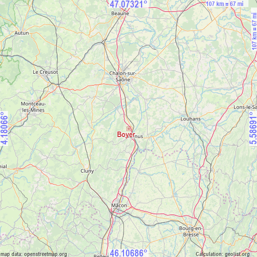
Boyer GPS coordinates[2]
46° 35' 31.884" North, 4° 53' 1.608" East
| Map corner | latitude | longitude |
|---|---|---|
| Upper-left | 47.07321°, | 4.18066° |
| Center: | 46.59219°, | 4.88378° |
| Lower-right: | 46.10686°, | 5.58691° |
| Map W x H: | 107.4×107.4 km | = 66.7×66.7mi |
| max Lat: | 51.07786° ⇑59.3% North |
| Boyer: | 46.59219° |
| min Lat: | ⇓40.7% South 41.3874° |
| min Long | Boyer | max Long |
| -5.08615° | 4.88378° | 9.52242° |
| W 76.3%⇐ | ⇒23.7% E |
Elevation
Elevation of Boyer is 195 m = 640 ft, and this is 1.3 m = 4 ft above average elevation for this country.
| Max E: |
2333 m = 7654 ft | 34.8% |
| Boyer | 195 m 640 ft | |
| Avg. | 193.7 m = 635 ft | |
Min E: |
-1 m = -3 ft | 65.2% |
See also: France elevation on elevation.city.
Geographical zone
Boyer is located in North temperate zone (between Tropic of Cancer and the Arctic Circle). Distance of this North polar circle is 2220.6 km =1379.8 mi to North.| Distance of | km | miles | from Boyer |
|---|---|---|---|
| North Pole | 4826.5 | 2999 | to North |
| Arctic Circle | 2220.6 | 1379.8 | to North |
| Tropic Cancer | 2574.6 | 1599.8 | to South |
| Equator | 5180.6 | 3219.1 | to South |


Nearby cities:
15 places around Boyer: (largest is in red/bold)
• Cuisery
9.6 km =6 mi,  114°
114°
• Gigny-sur-Saône
9.1 km =5.7 mi,  31°
31°
• Lacrost
5.3 km =3.3 mi,  135°
135°
• Laives
6.5 km =4 mi,  332°
332°
• Loisy
11 km =6.8 mi,  96°
96°
• Messey-sur-Grosne
12.2 km =7.6 mi,  298°
298°
• Nanton
6 km =3.7 mi, 301°
• Plottes
7 km =4.3 mi,  186°
186°
• Préty
7.1 km =4.4 mi, 140°
• Saint-Cyr
10.1 km =6.3 mi,  2°
2°
• Sennecey-le-Grand
5.6 km =3.5 mi,  346°
346°
• Sermoyer
12.6 km =7.8 mi, 144°
• Simandre
8.7 km =5.4 mi,  66°
66°
• Tournus
3.2 km =2 mi,  148°
148°
• Uchizy
9.9 km =6.2 mi,  179°
179°
Sources, notices
• [Note1] Compared only with cities in France existing in our database
• [Src1] Map data: © OpenStreetMap contributors (CC-BY-SA)
• [Src2] Other city data from geonames.org with taken over terms of usage.
• [Src3] Geographical zone / Annual Mean Temperature by Robert A. Rohde @ Wikipedia
