Tournus geodata
Tournus (Bourgogne-Franche-Comté) is a populated place; located in France in Europe/Paris (GMT+2) time zone. With population of 6,071 people, there are 1627 cities with bigger population in this country. Compared to other cities in France, 59.5% of cities are located further ↑North; 76.6% of cities are located further ←West and 64.9% of cities have lower elevation than Tournus. Note1
Administrative division(s):
- Level 1: Bourgogne-Franche-Comté
- Level 2: Département de Saône-et-Loire
- Level 3: Arrondissement de Mâcon
- Level 4: Tournus


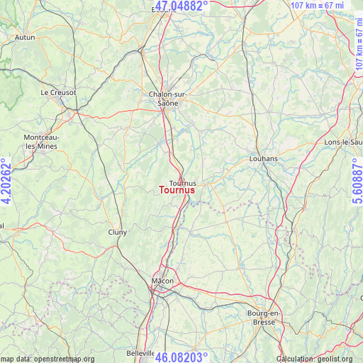
Tournus GPS coordinates[2]
46° 34' 3.288" North, 4° 54' 20.664" East
| Map corner | latitude | longitude |
|---|---|---|
| Upper-left | 47.04882°, | 4.20262° |
| Center: | 46.56758°, | 4.90574° |
| Lower-right: | 46.08203°, | 5.60887° |
| Map W x H: | 107.5×107.5 km | = 66.8×66.8mi |
| max Lat: | 51.07786° ⇑59.5% North |
| Tournus: | 46.56758° |
| min Lat: | ⇓40.5% South 41.3874° |
| min Long | Tournus | max Long |
| -5.08615° | 4.90574° | 9.52242° |
| W 76.6%⇐ | ⇒23.4% E |
Elevation
Elevation of Tournus is 193 m = 633 ft, and this is 0.69999999999999 m = 2 ft below average elevation for this country.
| Max E: |
2333 m = 7654 ft | 35.1% |
| Avg. | 193.7 m = 635 ft | |
| Tournus | 193 m = 633 ft | |
Min E: |
-1 m = -3 ft | 64.9% |
See also: France elevation on elevation.city.
Geographical zone
Tournus is located in North temperate zone (between Tropic of Cancer and the Arctic Circle). Distance of this North polar circle is 2223.3 km =1381.5 mi to North.| Distance of | km | miles | from Tournus |
|---|---|---|---|
| North Pole | 4829.2 | 3000.7 | to North |
| Arctic Circle | 2223.3 | 1381.5 | to North |
| Tropic Cancer | 2571.9 | 1598.1 | to South |
| Equator | 5177.8 | 3217.3 | to South |


Nearby cities:
15 places around Tournus: (largest is in red/bold)
• Boyer
3.2 km =2 mi,  328°
328°
• Cuisery
7.1 km =4.4 mi,  99°
99°
• Gigny-sur-Saône
10.9 km =6.8 mi,  16°
16°
• Lacrost
2.3 km =1.4 mi,  117°
117°
• Laives
9.7 km =6 mi, 331°
• Loisy
9.4 km =5.8 mi,  80°
80°
• Lugny
12.9 km =8 mi,  214°
214°
• Montbellet
10.5 km =6.5 mi,  193°
193°
• Nanton
9 km =5.6 mi,  310°
310°
• Plottes
4.9 km =3 mi, 209°
• Préty
3.9 km =2.4 mi,  134°
134°
• Sennecey-le-Grand
8.7 km =5.4 mi,  340°
340°
• Sermoyer
9.4 km =5.8 mi,  143°
143°
• Simandre
8.8 km =5.5 mi,  45°
45°
• Uchizy
7.3 km =4.5 mi, 192°
Sources, notices
• [Note1] Compared only with cities in France existing in our database
• [Src1] Map data: © OpenStreetMap contributors (CC-BY-SA)
• [Src2] Other city data from geonames.org with taken over terms of usage.
• [Src3] Geographical zone / Annual Mean Temperature by Robert A. Rohde @ Wikipedia
