Loisy geodata
Loisy (Bourgogne-Franche-Comté) is a populated place; located in France in Europe/Paris (GMT+2) time zone. With population of 532 people, there are 14567 cities with bigger population in this country. Compared to other cities in France, 59.4% of cities are located further ↑North; 77.9% of cities are located further ←West and 68.1% of cities have lower elevation than Loisy. Note1
Administrative division(s):
- Level 1: Bourgogne-Franche-Comté
- Level 2: Département de Saône-et-Loire
- Level 3: Arrondissement de Louhans
- Level 4: Loisy


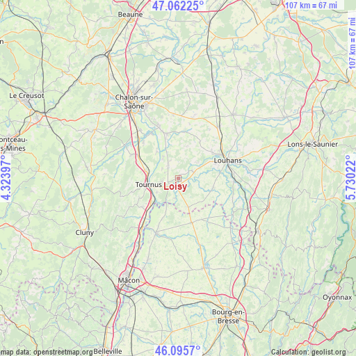
Loisy GPS coordinates[2]
46° 34' 52.068" North, 5° 1' 37.56" East
| Map corner | latitude | longitude |
|---|---|---|
| Upper-left | 47.06225°, | 4.32397° |
| Center: | 46.58113°, | 5.0271° |
| Lower-right: | 46.0957°, | 5.73022° |
| Map W x H: | 107.5×107.5 km | = 66.8×66.8mi |
| max Lat: | 51.07786° ⇑59.4% North |
| Loisy: | 46.58113° |
| min Lat: | ⇓40.6% South 41.3874° |
| min Long | Loisy | max Long |
| -5.08615° | 5.0271° | 9.52242° |
| W 77.9%⇐ | ⇒22.1% E |
Elevation
Elevation of Loisy is 210 m = 689 ft, and this is 16.3 m = 53 ft above average elevation for this country.
| Max E: |
2333 m = 7654 ft | 31.9% |
| Loisy | 210 m 689 ft | |
| Avg. | 193.7 m = 635 ft | |
Min E: |
-1 m = -3 ft | 68.1% |
See also: France elevation on elevation.city.
Geographical zone
Loisy is located in North temperate zone (between Tropic of Cancer and the Arctic Circle). Distance of this North polar circle is 2221.8 km =1380.6 mi to North.| Distance of | km | miles | from Loisy |
|---|---|---|---|
| North Pole | 4827.7 | 2999.8 | to North |
| Arctic Circle | 2221.8 | 1380.6 | to North |
| Tropic Cancer | 2573.4 | 1599 | to South |
| Equator | 5179.3 | 3218.3 | to South |


Nearby cities:
15 places around Loisy: (largest is in red/bold)
• Baudrières
10.3 km =6.4 mi,  353°
353°
• Boyer
11 km =6.8 mi,  276°
276°
• Cuisery
3.5 km =2.2 mi,  219°
219°
• Gigny-sur-Saône
10.9 km =6.8 mi,  325°
325°
• Lacrost
7.7 km =4.8 mi,  250°
250°
• Montpont-en-Bresse
10.9 km =6.8 mi,  104°
104°
• Montret
13 km =8.1 mi,  30°
30°
• Plottes
13 km =8.1 mi,  243°
243°
• Préty
7.8 km =4.8 mi, 236°
• Rancy
5.3 km =3.3 mi,  70°
70°
• Romenay
9.4 km =5.8 mi,  159°
159°
• Sermoyer
9.8 km =6.1 mi,  202°
202°
• Simandre
5.6 km =3.5 mi, 327°
• Sornay
12.9 km =8 mi,  64°
64°
• Tournus
9.4 km =5.8 mi,  260°
260°
Sources, notices
• [Note1] Compared only with cities in France existing in our database
• [Src1] Map data: © OpenStreetMap contributors (CC-BY-SA)
• [Src2] Other city data from geonames.org with taken over terms of usage.
• [Src3] Geographical zone / Annual Mean Temperature by Robert A. Rohde @ Wikipedia
