Simandres geodata
Simandres (Auvergne-Rhône-Alpes) is a populated place; located in France in Europe/Paris (GMT+2) time zone. With population of 1,323 people, there are 6928 cities with bigger population in this country. Compared to other cities in France, 72.2% of cities are located further ↑North; 76.1% of cities are located further ←West and 65.4% of cities have lower elevation than Simandres. Note1
Administrative division(s):
- Level 1: Auvergne-Rhône-Alpes
- Level 2: Département du Rhône
- Level 3: Arrondissement de Lyon
- Level 4: Simandres


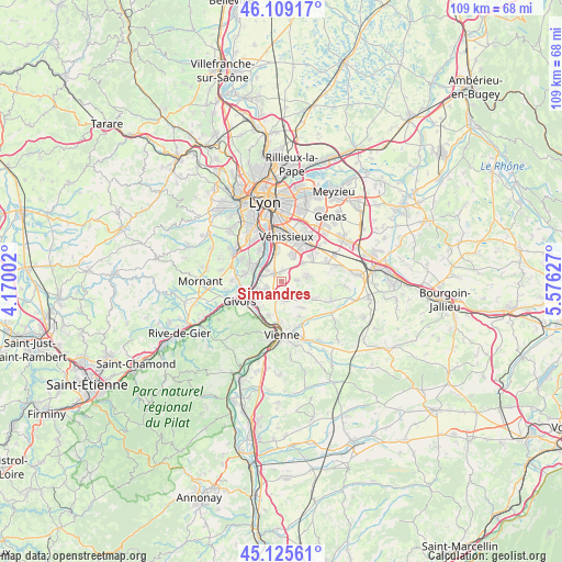
Simandres GPS coordinates[2]
45° 37' 10.38" North, 4° 52' 23.304" East
| Map corner | latitude | longitude |
|---|---|---|
| Upper-left | 46.10917°, | 4.17002° |
| Center: | 45.61955°, | 4.87314° |
| Lower-right: | 45.12561°, | 5.57627° |
| Map W x H: | 109.4×109.4 km | = 68×68mi |
| max Lat: | 51.07786° ⇑72.2% North |
| Simandres: | 45.61955° |
| min Lat: | ⇓27.8% South 41.3874° |
| min Long | Simandres | max Long |
| -5.08615° | 4.87314° | 9.52242° |
| W 76.1%⇐ | ⇒23.9% E |
Elevation
Elevation of Simandres is 196 m = 643 ft, and this is 2.3 m = 8 ft above average elevation for this country.
| Max E: |
2333 m = 7654 ft | 34.6% |
| Simandres | 196 m 643 ft | |
| Avg. | 193.7 m = 635 ft | |
Min E: |
-1 m = -3 ft | 65.4% |
See also: France elevation on elevation.city.
Geographical zone
Simandres is located in North temperate zone (between Tropic of Cancer and the Arctic Circle). Distance of this North polar circle is 2328.8 km =1447 mi to North.| Distance of | km | miles | from Simandres |
|---|---|---|---|
| North Pole | 4934.6 | 3066.2 | to North |
| Arctic Circle | 2328.8 | 1447 | to North |
| Tropic Cancer | 2466.5 | 1532.6 | to South |
| Equator | 5072.4 | 3151.8 | to South |


Nearby cities:
15 places around Simandres: (largest is in red/bold)
• Chaponnay
5 km =3.1 mi,  79°
79°
• Charly
6.9 km =4.3 mi,  298°
298°
• Chasse-sur-Rhône
6.7 km =4.2 mi,  227°
227°
• Chuzelles
3.9 km =2.4 mi,  175°
175°
• Communay
3.4 km =2.1 mi,  240°
240°
• Corbas
5.8 km =3.6 mi,  22°
22°
• Feyzin
6 km =3.7 mi,  349°
349°
• Grigny
6.6 km =4.1 mi,  259°
259°
• Irigny
7.1 km =4.4 mi,  326°
326°
• Marennes
3.1 km =1.9 mi,  87°
87°
• Solaize
3.4 km =2.1 mi,  311°
311°
• Sérézin-du-Rhône
4 km =2.5 mi,  284°
284°
• Ternay
5.2 km =3.2 mi,  248°
248°
• Vernaison
5.7 km =3.5 mi, 303°
• Villette-de-Vienne
4.6 km =2.9 mi,  134°
134°
Sources, notices
• [Note1] Compared only with cities in France existing in our database
• [Src1] Map data: © OpenStreetMap contributors (CC-BY-SA)
• [Src2] Other city data from geonames.org with taken over terms of usage.
• [Src3] Geographical zone / Annual Mean Temperature by Robert A. Rohde @ Wikipedia
