Luzinay geodata
Luzinay (Auvergne-Rhône-Alpes) is a populated place; located in France in Europe/Paris (GMT+2) time zone. With population of 2,139 people, there are 4488 cities with bigger population in this country. Compared to other cities in France, 72.7% of cities are located further ↑North; 77.3% of cities are located further ←West and 74% of cities have lower elevation than Luzinay. Note1
Administrative division(s):
- Level 1: Auvergne-Rhône-Alpes
- Level 2: Département de l'Isère
- Level 3: Arrondissement de Vienne
- Level 4: Luzinay


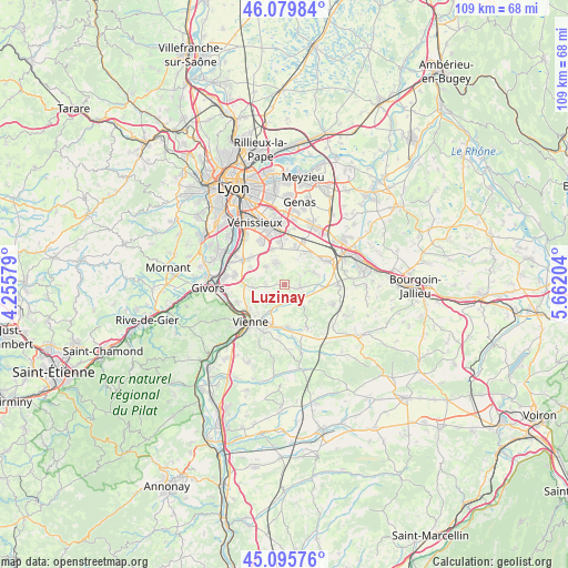
Luzinay GPS coordinates[2]
45° 35' 23.856" North, 4° 57' 32.076" East
| Map corner | latitude | longitude |
|---|---|---|
| Upper-left | 46.07984°, | 4.25579° |
| Center: | 45.58996°, | 4.95891° |
| Lower-right: | 45.09576°, | 5.66204° |
| Map W x H: | 109.4×109.4 km | = 68×68mi |
| max Lat: | 51.07786° ⇑72.7% North |
| Luzinay: | 45.58996° |
| min Lat: | ⇓27.3% South 41.3874° |
| min Long | Luzinay | max Long |
| -5.08615° | 4.95891° | 9.52242° |
| W 77.3%⇐ | ⇒22.7% E |
Elevation
Elevation of Luzinay is 242 m = 794 ft, and this is 48.3 m = 158 ft above average elevation for this country.
| Max E: |
2333 m = 7654 ft | 26% |
| Luzinay | 242 m 794 ft | |
| Avg. | 193.7 m = 635 ft | |
Min E: |
-1 m = -3 ft | 74% |
See also: France elevation on elevation.city.
Geographical zone
Luzinay is located in North temperate zone (between Tropic of Cancer and the Arctic Circle). Distance of this North polar circle is 2332 km =1449 mi to North.| Distance of | km | miles | from Luzinay |
|---|---|---|---|
| North Pole | 4937.9 | 3068.3 | to North |
| Arctic Circle | 2332 | 1449 | to North |
| Tropic Cancer | 2463.2 | 1530.6 | to South |
| Equator | 5069.1 | 3149.8 | to South |


Nearby cities:
15 places around Luzinay: (largest is in red/bold)
• Chaponnay
4.5 km =2.8 mi,  337°
337°
• Chuzelles
6.4 km =4 mi,  264°
264°
• Estrablin
8.3 km =5.2 mi,  178°
178°
• Marennes
5 km =3.1 mi,  313°
313°
• Mions
8.1 km =5 mi,  356°
356°
• Oytier-Saint-Oblas
6.7 km =4.2 mi,  122°
122°
• Pont-Évêque
7.5 km =4.7 mi,  211°
211°
• Saint-Just-Chaleyssin
3.1 km =1.9 mi,  81°
81°
• Saint-Pierre-de-Chandieu
7.6 km =4.7 mi,  34°
34°
• Septème
5.5 km =3.4 mi,  138°
138°
• Serpaize
4.8 km =3 mi,  222°
222°
• Simandres
7.4 km =4.6 mi,  296°
296°
• Toussieu
7.4 km =4.6 mi,  15°
15°
• Valencin
6 km =3.7 mi,  66°
66°
• Villette-de-Vienne
3.4 km =2.1 mi,  270°
270°
Sources, notices
• [Note1] Compared only with cities in France existing in our database
• [Src1] Map data: © OpenStreetMap contributors (CC-BY-SA)
• [Src2] Other city data from geonames.org with taken over terms of usage.
• [Src3] Geographical zone / Annual Mean Temperature by Robert A. Rohde @ Wikipedia
