La Chapelle-Vendômoise geodata
La Chapelle-Vendômoise (Centre) is a populated place; located in France in Europe/Paris (GMT+2) time zone. With population of 772 people, there are 10917 cities with bigger population in this country. Compared to other cities in France, 53.8% of cities are located further ↓South; 66.3% of cities are located further →East and 54.8% of cities have higher elevation than La Chapelle-Vendômoise. Note1
Administrative division(s):
- Level 1: Centre
- Level 2: Département du Loir-et-Cher
- Level 3: Arrondissement de Blois
- Level 4: La Chapelle-Vendômoise
Current local time in La Chapelle-Vendômoise:
07:32 AM, SaturdayDifference from your time zone: hours


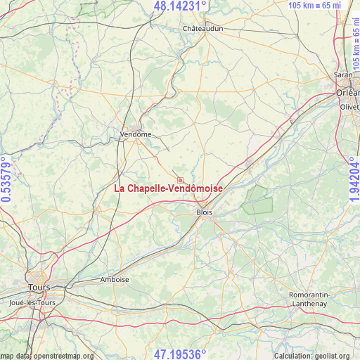
La Chapelle-Vendômoise GPS coordinates[2]
47° 40' 15.528" North, 1° 14' 20.076" East
| Map corner | latitude | longitude |
|---|---|---|
| Upper-left | 48.14231°, | 0.53579° |
| Center: | 47.67098°, | 1.23891° |
| Lower-right: | 47.19536°, | 1.94204° |
| Map W x H: | 105.3×105.3 km | = 65.4×65.4mi |
| max Lat: | 51.07786° ⇑46.2% North |
| La Chapelle-Vendômoise: | 47.67098° |
| min Lat: | ⇓53.8% South 41.3874° |
| min Long | La Chapelle-Ven | max Long |
| -5.08615° | 1.23891° | 9.52242° |
| W 33.7%⇐ | ⇒66.3% E |
Elevation
Elevation of La Chapelle-Vendômoise is 117 m = 384 ft, and this is 76.7 m = 252 ft below average elevation for this country.
| Max E: |
2333 m = 7654 ft | 54.8% |
| Avg. | 193.7 m = 635 ft | |
| La Chapelle-Vendômoise | 117 m = 384 ft | |
Min E: |
-1 m = -3 ft | 45.2% |
See also: France elevation on elevation.city.
Geographical zone
La Chapelle-Vendômoise is located in North temperate zone (between Tropic of Cancer and the Arctic Circle). Distance of this North polar circle is 2100.7 km =1305.3 mi to North.| Distance of | km | miles | from La Chapelle-Vendômoise |
|---|---|---|---|
| North Pole | 4706.5 | 2924.5 | to North |
| Arctic Circle | 2100.7 | 1305.3 | to North |
| Tropic Cancer | 2694.6 | 1674.3 | to South |
| Equator | 5300.5 | 3293.6 | to South |


Nearby cities:
15 places around La Chapelle-Vendômoise: (largest is in red/bold)
• Averdon
4.4 km =2.7 mi,  71°
71°
• Blois
10.9 km =6.8 mi,  141°
141°
• Champigny-en-Beauce
4.7 km =2.9 mi,  13°
13°
• Fossé
5.4 km =3.4 mi, 141°
• Herbault
10.5 km =6.5 mi,  225°
225°
• La Chaussée-Saint-Victor
11.4 km =7.1 mi,  122°
122°
• Landes-le-Gaulois
4.5 km =2.8 mi,  245°
245°
• Marolles
5.7 km =3.5 mi, 116°
• Molineuf
10.6 km =6.6 mi,  188°
188°
• Orchaise
9.4 km =5.8 mi,  198°
198°
• Saint-Lubin-en-Vergonnois
6.4 km =4 mi,  183°
183°
• Saint-Sulpice-de-Pommeray
8.2 km =5.1 mi,  165°
165°
• Selommes
10 km =6.2 mi,  340°
340°
• Villebarou
8.2 km =5.1 mi,  130°
130°
• Villerbon
10 km =6.2 mi,  95°
95°
Sources, notices
• [Note1] Compared only with cities in France existing in our database
• [Src1] Map data: © OpenStreetMap contributors (CC-BY-SA)
• [Src2] Other city data from geonames.org with taken over terms of usage.
• [Src3] Geographical zone / Annual Mean Temperature by Robert A. Rohde @ Wikipedia
