Landes-le-Gaulois geodata
Landes-le-Gaulois (Centre) is a populated place; located in France in Europe/Paris (GMT+2) time zone. With population of 600 people, there are 13316 cities with bigger population in this country. Compared to other cities in France, 53.5% of cities are located further ↓South; 67% of cities are located further →East and 59.1% of cities have higher elevation than Landes-le-Gaulois. Note1
Administrative division(s):
- Level 1: Centre
- Level 2: Département du Loir-et-Cher
- Level 3: Arrondissement de Blois
- Level 4: Landes-le-Gaulois


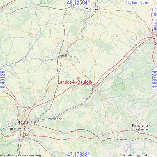
Landes-le-Gaulois GPS coordinates[2]
47° 39' 14.976" North, 1° 11' 3.876" East
| Map corner | latitude | longitude |
|---|---|---|
| Upper-left | 48.12564°, | 0.48129° |
| Center: | 47.65416°, | 1.18441° |
| Lower-right: | 47.17838°, | 1.88754° |
| Map W x H: | 105.3×105.3 km | = 65.4×65.4mi |
| max Lat: | 51.07786° ⇑46.5% North |
| Landes-le-Gaulois: | 47.65416° |
| min Lat: | ⇓53.5% South 41.3874° |
| min Long | Landes-le-Gaulo | max Long |
| -5.08615° | 1.18441° | 9.52242° |
| W 33%⇐ | ⇒67% E |
Elevation
Elevation of Landes-le-Gaulois is 105 m = 344 ft, and this is 88.7 m = 291 ft below average elevation for this country.
| Max E: |
2333 m = 7654 ft | 59.1% |
| Avg. | 193.7 m = 635 ft | |
| Landes-le-Gaulois | 105 m = 344 ft | |
Min E: |
-1 m = -3 ft | 40.9% |
See also: France elevation on elevation.city.
Geographical zone
Landes-le-Gaulois is located in North temperate zone (between Tropic of Cancer and the Arctic Circle). Distance of this North polar circle is 2102.5 km =1306.4 mi to North.| Distance of | km | miles | from Landes-le-Gaulois |
|---|---|---|---|
| North Pole | 4708.4 | 2925.7 | to North |
| Arctic Circle | 2102.5 | 1306.4 | to North |
| Tropic Cancer | 2692.7 | 1673.2 | to South |
| Equator | 5298.6 | 3292.4 | to South |


Nearby cities:
15 places around Landes-le-Gaulois: (largest is in red/bold)
• Averdon
8.9 km =5.5 mi,  68°
68°
• Blois
12.7 km =7.9 mi,  121°
121°
• Chambon-sur-Cisse
10.5 km =6.5 mi,  167°
167°
• Champigny-en-Beauce
8.3 km =5.2 mi,  38°
38°
• Fossé
7.8 km =4.8 mi,  107°
107°
• Herbault
6.4 km =4 mi,  211°
211°
• La Chapelle-Vendômoise
4.5 km =2.8 mi, 65°
• Marolles
9.2 km =5.7 mi,  94°
94°
• Molineuf
9 km =5.6 mi,  163°
163°
• Orchaise
7.1 km =4.4 mi, 171°
• Saint-Amand-Longpré
13 km =8.1 mi,  284°
284°
• Saint-Lubin-en-Vergonnois
5.8 km =3.6 mi,  140°
140°
• Saint-Sulpice-de-Pommeray
8.6 km =5.3 mi,  134°
134°
• Selommes
11.3 km =7 mi,  3°
3°
• Villebarou
10.9 km =6.8 mi, 108°
Sources, notices
• [Note1] Compared only with cities in France existing in our database
• [Src1] Map data: © OpenStreetMap contributors (CC-BY-SA)
• [Src2] Other city data from geonames.org with taken over terms of usage.
• [Src3] Geographical zone / Annual Mean Temperature by Robert A. Rohde @ Wikipedia
