L’Isle-en-Dodon geodata
L’Isle-en-Dodon (Occitanie) is a populated place; located in France in Europe/Paris (GMT+2) time zone. With population of 2,034 people, there are 4717 cities with bigger population in this country. Compared to other cities in France, 94.4% of cities are located further ↑North; 70.3% of cities are located further →East and 67% of cities have lower elevation than L’Isle-en-Dodon. Note1
Administrative division(s):
- Level 1: Occitanie
- Level 2: Haute-Garonne
- Level 3: Arrondissement de Saint-Gaudens
- Level 4: L'Isle-en-Dodon


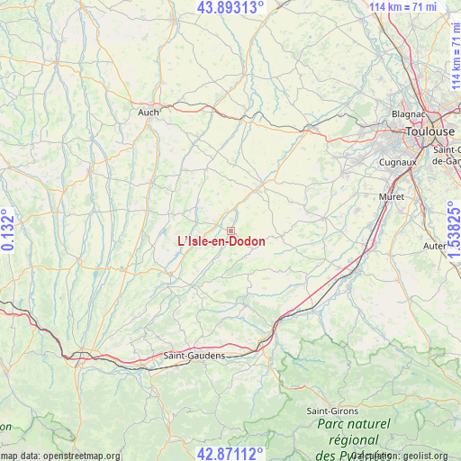
L’Isle-en-Dodon GPS coordinates[2]
43° 23' 3.408" North, 0° 50' 6.468" East
| Map corner | latitude | longitude |
|---|---|---|
| Upper-left | 43.89313°, | 0.132° |
| Center: | 43.38428°, | 0.83513° |
| Lower-right: | 42.87112°, | 1.53825° |
| Map W x H: | 113.6×113.6 km | = 70.6×70.6mi |
| max Lat: | 51.07786° ⇑94.4% North |
| L’Isle-en-Dodon: | 43.38428° |
| min Lat: | ⇓5.6% South 41.3874° |
| min Long | L’Isle-en-Dod | max Long |
| -5.08615° | 0.83513° | 9.52242° |
| W 29.7%⇐ | ⇒70.3% E |
Elevation
Elevation of L’Isle-en-Dodon is 204 m = 669 ft, and this is 10.3 m = 34 ft above average elevation for this country.
| Max E: |
2333 m = 7654 ft | 33% |
| L’Isle-en-Dodon | 204 m 669 ft | |
| Avg. | 193.7 m = 635 ft | |
Min E: |
-1 m = -3 ft | 67% |
See also: France elevation on elevation.city.
Geographical zone
L’Isle-en-Dodon is located in North temperate zone (between Tropic of Cancer and the Arctic Circle). Distance of this Northern Tropic circle is 2218 km =1378.2 mi to South.| Distance of | km | miles | from L’Isle-en-Dodon |
|---|---|---|---|
| North Pole | 5183.2 | 3220.7 | to North |
| Arctic Circle | 2577.3 | 1601.5 | to North |
| Tropic Cancer | 2218 | 1378.2 | to South |
| Equator | 4823.9 | 2997.4 | to South |


Nearby cities:
15 places around L’Isle-en-Dodon: (largest is in red/bold)
• Aurignac
19 km =11.8 mi,  168°
168°
• Blajan
20.8 km =12.9 mi,  228°
228°
• Boulogne-sur-Gesse
17.7 km =11 mi,  237°
237°
• Endoufielle
23.5 km =14.6 mi,  38°
38°
• Le Fousseret
21.9 km =13.6 mi,  121°
121°
• Lombez
11.8 km =7.3 mi,  31°
31°
• Martres-Tolosane
25 km =15.5 mi,  145°
145°
• Masseube
21.4 km =13.3 mi,  283°
283°
• Mondavezan
22.9 km =14.2 mi,  134°
134°
• Rieumes
23 km =14.3 mi,  82°
82°
• Saint-Thomas
24.6 km =15.3 mi,  54°
54°
• Samatan
14.3 km =8.9 mi, 32°
• Saramon
16.5 km =10.3 mi,  339°
339°
• Seissan
23 km =14.3 mi,  301°
301°
• Simorre
11 km =6.8 mi,  312°
312°
Sources, notices
• [Note1] Compared only with cities in France existing in our database
• [Src1] Map data: © OpenStreetMap contributors (CC-BY-SA)
• [Src2] Other city data from geonames.org with taken over terms of usage.
• [Src3] Geographical zone / Annual Mean Temperature by Robert A. Rohde @ Wikipedia
