Aubiet geodata
Aubiet (Occitanie) is a populated place; located in France in Europe/Paris (GMT+2) time zone. With population of 1,046 people, there are 8496 cities with bigger population in this country. Compared to other cities in France, 91.3% of cities are located further ↑North; 70.6% of cities are located further →East and 62.9% of cities have lower elevation than Aubiet. Note1


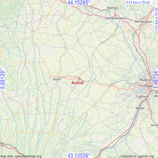
Aubiet GPS coordinates[2]
43° 38' 46.716" North, 0° 47' 3.876" East
| Map corner | latitude | longitude |
|---|---|---|
| Upper-left | 44.15295°, | 0.08129° |
| Center: | 43.64631°, | 0.78441° |
| Lower-right: | 43.13536°, | 1.48754° |
| Map W x H: | 113.1×113.1 km | = 70.3×70.3mi |
| max Lat: | 51.07786° ⇑91.3% North |
| Aubiet: | 43.64631° |
| min Lat: | ⇓8.7% South 41.3874° |
| min Long | Aubiet | max Long |
| -5.08615° | 0.78441° | 9.52242° |
| W 29.4%⇐ | ⇒70.6% E |
Elevation
Elevation of Aubiet is 184 m = 604 ft, and this is 9.7 m = 32 ft below average elevation for this country.
| Max E: |
2333 m = 7654 ft | 37.1% |
| Avg. | 193.7 m = 635 ft | |
| Aubiet | 184 m = 604 ft | |
Min E: |
-1 m = -3 ft | 62.9% |
See also: France elevation on elevation.city.
Geographical zone
Aubiet is located in North temperate zone (between Tropic of Cancer and the Arctic Circle). Distance of this Northern Tropic circle is 2247.1 km =1396.3 mi to South.| Distance of | km | miles | from Aubiet |
|---|---|---|---|
| North Pole | 5154 | 3202.5 | to North |
| Arctic Circle | 2548.2 | 1583.4 | to North |
| Tropic Cancer | 2247.1 | 1396.3 | to South |
| Equator | 4853 | 3015.5 | to South |


Nearby cities:
15 places around Aubiet: (largest is in red/bold)
• Auch
15.8 km =9.8 mi,  269°
269°
• Auterive
15.5 km =9.6 mi,  242°
242°
• Cologne
17.7 km =11 mi,  61°
61°
• Duran
17.8 km =11.1 mi,  277°
277°
• Escornebœuf
9.3 km =5.8 mi,  87°
87°
• Gimont
7.7 km =4.8 mi,  106°
106°
• Mauvezin
12 km =7.5 mi,  38°
38°
• Monferran-Savès
16.7 km =10.4 mi, 108°
• Montestruc-sur-Gers
20.6 km =12.8 mi,  322°
322°
• Pavie
16.1 km =10 mi,  255°
255°
• Pessan
11.3 km =7 mi, 255°
• Preignan
14.7 km =9.1 mi,  299°
299°
• Roquelaure
18.5 km =11.5 mi, 295°
• Saramon
13.8 km =8.6 mi,  187°
187°
• Touget
11.5 km =7.1 mi,  65°
65°
Sources, notices
• [Note1] Compared only with cities in France existing in our database
• [Src1] Map data: © OpenStreetMap contributors (CC-BY-SA)
• [Src2] Other city data from geonames.org with taken over terms of usage.
• [Src3] Geographical zone / Annual Mean Temperature by Robert A. Rohde @ Wikipedia
