Simorre geodata
Simorre (Occitanie) is a populated place; located in France in Europe/Paris (GMT+1) time zone. With population of 730 people, there are 11410 cities with bigger population in this country. Compared to other cities in France, 93.7% of cities are located further ↑North; 71.1% of cities are located further →East and 67% of cities have lower elevation than Simorre. Note1


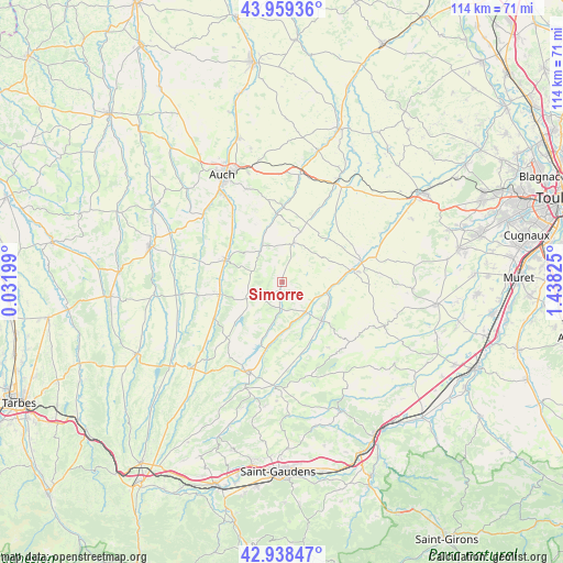
Simorre GPS coordinates[2]
43° 27' 3.852" North, 0° 44' 6.432" East
| Map corner | latitude | longitude |
|---|---|---|
| Upper-left | 43.95936°, | 0.03199° |
| Center: | 43.45107°, | 0.73512° |
| Lower-right: | 42.93847°, | 1.43825° |
| Map W x H: | 113.5×113.5 km | = 70.5×70.5mi |
| max Lat: | 51.07786° ⇑93.7% North |
| Simorre: | 43.45107° |
| min Lat: | ⇓6.3% South 41.3874° |
| min Long | Simorre | max Long |
| -5.08615° | 0.73512° | 9.52242° |
| W 28.9%⇐ | ⇒71.1% E |
Elevation
Elevation of Simorre is 204 m = 669 ft, and this is 10.3 m = 34 ft above average elevation for this country.
| Max E: |
2333 m = 7654 ft | 33% |
| Simorre | 204 m 669 ft | |
| Avg. | 193.7 m = 635 ft | |
Min E: |
-1 m = -3 ft | 67% |
See also: France elevation on elevation.city.
Geographical zone
Simorre is located in North temperate zone (between Tropic of Cancer and the Arctic Circle). Distance of this Northern Tropic circle is 2225.4 km =1382.8 mi to South.| Distance of | km | miles | from Simorre |
|---|---|---|---|
| North Pole | 5175.8 | 3216.1 | to North |
| Arctic Circle | 2569.9 | 1596.9 | to North |
| Tropic Cancer | 2225.4 | 1382.8 | to South |
| Equator | 4831.3 | 3002 | to South |


Nearby cities:
15 places around Simorre: (largest is in red/bold)
• Aubiet
22.1 km =13.7 mi,  10°
10°
• Auch
24.6 km =15.3 mi,  331°
331°
• Auterive
17.6 km =10.9 mi, 326°
• Blajan
22.6 km =14 mi,  199°
199°
• Boulogne-sur-Gesse
18.2 km =11.3 mi, 202°
• Endoufielle
25.2 km =15.7 mi,  64°
64°
• Gimont
22.6 km =14 mi,  30°
30°
• Lombez
14.5 km =9 mi,  79°
79°
• L’Isle-en-Dodon
11 km =6.8 mi,  132°
132°
• Masseube
12.9 km =8 mi,  259°
259°
• Pavie
21.1 km =13.1 mi, 326°
• Pessan
20.2 km =12.6 mi,  339°
339°
• Samatan
16.4 km =10.2 mi,  73°
73°
• Saramon
8.3 km =5.2 mi,  15°
15°
• Seissan
12.4 km =7.7 mi,  291°
291°
Sources, notices
• [Note1] Compared only with cities in France existing in our database
• [Src1] Map data: © OpenStreetMap contributors (CC-BY-SA)
• [Src2] Other city data from geonames.org with taken over terms of usage.
• [Src3] Geographical zone / Annual Mean Temperature by Robert A. Rohde @ Wikipedia
