Saramon geodata
Saramon (Occitanie) is a populated place; located in France in Europe/Paris (GMT+2) time zone. With population of 720 people, there are 11535 cities with bigger population in this country. Compared to other cities in France, 92.8% of cities are located further ↑North; 70.9% of cities are located further →East and 65.4% of cities have lower elevation than Saramon. Note1


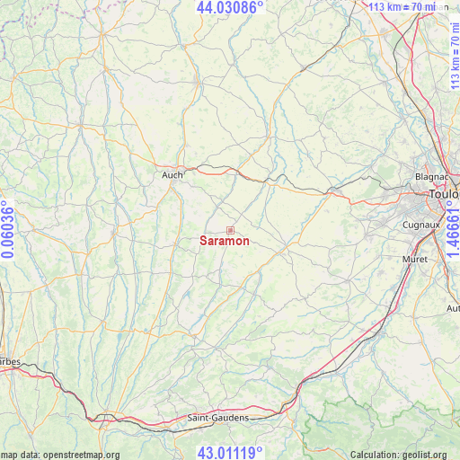
Saramon GPS coordinates[2]
43° 31' 23.448" North, 0° 45' 48.564" East
| Map corner | latitude | longitude |
|---|---|---|
| Upper-left | 44.03086°, | 0.06036° |
| Center: | 43.52318°, | 0.76349° |
| Lower-right: | 43.01119°, | 1.46661° |
| Map W x H: | 113.4×113.4 km | = 70.5×70.5mi |
| max Lat: | 51.07786° ⇑92.8% North |
| Saramon: | 43.52318° |
| min Lat: | ⇓7.2% South 41.3874° |
| min Long | Saramon | max Long |
| -5.08615° | 0.76349° | 9.52242° |
| W 29.1%⇐ | ⇒70.9% E |
Elevation
Elevation of Saramon is 196 m = 643 ft, and this is 2.3 m = 8 ft above average elevation for this country.
| Max E: |
2333 m = 7654 ft | 34.6% |
| Saramon | 196 m 643 ft | |
| Avg. | 193.7 m = 635 ft | |
Min E: |
-1 m = -3 ft | 65.4% |
See also: France elevation on elevation.city.
Geographical zone
Saramon is located in North temperate zone (between Tropic of Cancer and the Arctic Circle). Distance of this Northern Tropic circle is 2233.4 km =1387.8 mi to South.| Distance of | km | miles | from Saramon |
|---|---|---|---|
| North Pole | 5167.7 | 3211.1 | to North |
| Arctic Circle | 2561.9 | 1591.9 | to North |
| Tropic Cancer | 2233.4 | 1387.8 | to South |
| Equator | 4839.3 | 3007 | to South |


Nearby cities:
15 places around Saramon: (largest is in red/bold)
• Aubiet
13.8 km =8.6 mi,  7°
7°
• Auch
19.6 km =12.2 mi,  313°
313°
• Auterive
13.7 km =8.5 mi,  298°
298°
• Endoufielle
20.6 km =12.8 mi,  81°
81°
• Escornebœuf
17.9 km =11.1 mi,  37°
37°
• Gimont
14.6 km =9.1 mi, 38°
• Lombez
13.1 km =8.1 mi,  114°
114°
• L’Isle-en-Dodon
16.5 km =10.3 mi,  159°
159°
• Masseube
18.2 km =11.3 mi,  235°
235°
• Monferran-Savès
19.4 km =12.1 mi,  64°
64°
• Pavie
16.9 km =10.5 mi, 304°
• Pessan
14.3 km =8.9 mi,  319°
319°
• Samatan
13.8 km =8.6 mi,  104°
104°
• Seissan
14.2 km =8.8 mi,  255°
255°
• Simorre
8.3 km =5.2 mi,  195°
195°
Sources, notices
• [Note1] Compared only with cities in France existing in our database
• [Src1] Map data: © OpenStreetMap contributors (CC-BY-SA)
• [Src2] Other city data from geonames.org with taken over terms of usage.
• [Src3] Geographical zone / Annual Mean Temperature by Robert A. Rohde @ Wikipedia
