Séglien geodata
Séglien (Brittany) is a populated place; located in France in Europe/Paris (GMT+2) time zone. With population of 764 people, there are 11016 cities with bigger population in this country. Compared to other cities in France, 61.3% of cities are located further ↓South; 97.7% of cities are located further →East and 70.9% of cities have lower elevation than Séglien. Note1
Administrative division(s):
- Level 1: Brittany
- Level 2: Morbihan
- Level 3: Arrondissement de Pontivy
- Level 4: Séglien


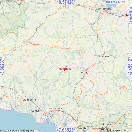
Séglien GPS coordinates[2]
48° 6' 24.84" North, 3° 9' 33.3" West
| Map corner | latitude | longitude |
|---|---|---|
| Upper-left | 48.57426°, | -3.86237° |
| Center: | 48.1069°, | -3.15925° |
| Lower-right: | 47.63525°, | -2.45612° |
| Map W x H: | 104.4×104.4 km | = 64.9×64.9mi |
| max Lat: | 51.07786° ⇑38.7% North |
| Séglien: | 48.1069° |
| min Lat: | ⇓61.3% South 41.3874° |
| min Long | Séglien | max Long |
| -5.08615° | -3.15925° | 9.52242° |
| W 2.3%⇐ | ⇒97.7% E |
Elevation
Elevation of Séglien is 223 m = 732 ft, and this is 29.3 m = 96 ft above average elevation for this country.
| Max E: |
2333 m = 7654 ft | 29.1% |
| Séglien | 223 m 732 ft | |
| Avg. | 193.7 m = 635 ft | |
Min E: |
-1 m = -3 ft | 70.9% |
See also: France elevation on elevation.city.
Geographical zone
Séglien is located in North temperate zone (between Tropic of Cancer and the Arctic Circle). Distance of this North polar circle is 2052.2 km =1275.2 mi to North.| Distance of | km | miles | from Séglien |
|---|---|---|---|
| North Pole | 4658.1 | 2894.4 | to North |
| Arctic Circle | 2052.2 | 1275.2 | to North |
| Tropic Cancer | 2743.1 | 1704.5 | to South |
| Equator | 5349 | 3323.7 | to South |


Nearby cities:
15 places around Séglien: (largest is in red/bold)
• Bieuzy
15.4 km =9.6 mi,  153°
153°
• Cléguérec
6.8 km =4.2 mi,  72°
72°
• Gouarec
13.5 km =8.4 mi,  353°
353°
• Guern
10 km =6.2 mi, 149°
• Guémené-sur-Scorff
5.4 km =3.4 mi,  214°
214°
• Laniscat
15.3 km =9.5 mi,  10°
10°
• Le Sourn
14.6 km =9.1 mi,  119°
119°
• Lignol
11.4 km =7.1 mi,  226°
226°
• Malguénac
8.5 km =5.3 mi,  110°
110°
• Melrand
14.6 km =9.1 mi,  165°
165°
• Neulliac
13.3 km =8.3 mi,  79°
79°
• Ploërdut
9.6 km =6 mi,  256°
256°
• Plélauff
11.6 km =7.2 mi,  341°
341°
• Pontivy
15.2 km =9.4 mi, 106°
• Saint-Aignan
13.6 km =8.5 mi,  52°
52°
Sources, notices
• [Note1] Compared only with cities in France existing in our database
• [Src1] Map data: © OpenStreetMap contributors (CC-BY-SA)
• [Src2] Other city data from geonames.org with taken over terms of usage.
• [Src3] Geographical zone / Annual Mean Temperature by Robert A. Rohde @ Wikipedia
