Guern geodata
Guern (Brittany) is a populated place; located in France in Europe/Paris (GMT+2) time zone. With population of 1,500 people, there are 6188 cities with bigger population in this country. Compared to other cities in France, 59.8% of cities are located further ↓South; 97.5% of cities are located further →East and 52.2% of cities have lower elevation than Guern. Note1
Administrative division(s):
- Level 1: Brittany
- Level 2: Morbihan
- Level 3: Arrondissement de Pontivy
- Level 4: Guern


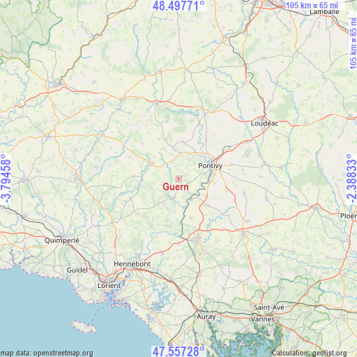
Guern GPS coordinates[2]
48° 1' 46.704" North, 3° 5' 29.22" West
| Map corner | latitude | longitude |
|---|---|---|
| Upper-left | 48.49771°, | -3.79458° |
| Center: | 48.02964°, | -3.09145° |
| Lower-right: | 47.55728°, | -2.38833° |
| Map W x H: | 104.6×104.6 km | = 65×65mi |
| max Lat: | 51.07786° ⇑40.2% North |
| Guern: | 48.02964° |
| min Lat: | ⇓59.8% South 41.3874° |
| min Long | Guern | max Long |
| -5.08615° | -3.09145° | 9.52242° |
| W 2.5%⇐ | ⇒97.5% E |
Elevation
Elevation of Guern is 140 m = 459 ft, and this is 53.7 m = 176 ft below average elevation for this country.
| Max E: |
2333 m = 7654 ft | 47.8% |
| Avg. | 193.7 m = 635 ft | |
| Guern | 140 m = 459 ft | |
Min E: |
-1 m = -3 ft | 52.2% |
See also: France elevation on elevation.city.
Geographical zone
Guern is located in North temperate zone (between Tropic of Cancer and the Arctic Circle). Distance of this North polar circle is 2060.8 km =1280.5 mi to North.| Distance of | km | miles | from Guern |
|---|---|---|---|
| North Pole | 4666.7 | 2899.8 | to North |
| Arctic Circle | 2060.8 | 1280.5 | to North |
| Tropic Cancer | 2734.5 | 1699.1 | to South |
| Equator | 5340.4 | 3318.4 | to South |


Nearby cities:
15 places around Guern: (largest is in red/bold)
• Bieuzy
5.5 km =3.4 mi,  160°
160°
• Bubry
9.5 km =5.9 mi,  218°
218°
• Cléguérec
10.8 km =6.7 mi,  7°
7°
• Guémené-sur-Scorff
9.1 km =5.7 mi,  297°
297°
• Le Sourn
7.8 km =4.8 mi,  79°
79°
• Lignol
13.3 km =8.3 mi,  273°
273°
• Malguénac
6.3 km =3.9 mi,  27°
27°
• Melrand
5.7 km =3.5 mi,  193°
193°
• Moustoir-Remungol
14.6 km =9.1 mi,  104°
104°
• Neulliac
13.6 km =8.5 mi,  36°
36°
• Pluméliau
11.8 km =7.3 mi,  132°
132°
• Pontivy
10.5 km =6.5 mi,  65°
65°
• Quistinic
14.3 km =8.9 mi, 192°
• Saint-Thuriau
10.6 km =6.6 mi, 97°
• Séglien
10 km =6.2 mi,  329°
329°
Sources, notices
• [Note1] Compared only with cities in France existing in our database
• [Src1] Map data: © OpenStreetMap contributors (CC-BY-SA)
• [Src2] Other city data from geonames.org with taken over terms of usage.
• [Src3] Geographical zone / Annual Mean Temperature by Robert A. Rohde @ Wikipedia
