Melrand geodata
Melrand (Brittany) is a populated place; located in France in Europe/Paris (GMT+2) time zone. With population of 1,631 people, there are 5728 cities with bigger population in this country. Compared to other cities in France, 58.9% of cities are located further ↓South; 97.5% of cities are located further →East and 74.6% of cities have higher elevation than Melrand. Note1
Administrative division(s):
- Level 1: Brittany
- Level 2: Morbihan
- Level 3: Arrondissement de Pontivy
- Level 4: Melrand


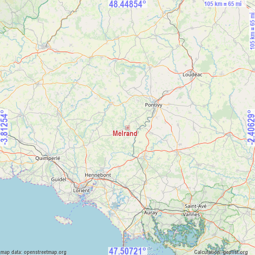
Melrand GPS coordinates[2]
47° 58' 48.072" North, 3° 6' 33.876" West
| Map corner | latitude | longitude |
|---|---|---|
| Upper-left | 48.44854°, | -3.81254° |
| Center: | 47.98002°, | -3.10941° |
| Lower-right: | 47.50721°, | -2.40629° |
| Map W x H: | 104.7×104.7 km | = 65.1×65.1mi |
| max Lat: | 51.07786° ⇑41.1% North |
| Melrand: | 47.98002° |
| min Lat: | ⇓58.9% South 41.3874° |
| min Long | Melrand | max Long |
| -5.08615° | -3.10941° | 9.52242° |
| W 2.5%⇐ | ⇒97.5% E |
Elevation
Elevation of Melrand is 68 m = 223 ft, and this is 125.7 m = 412 ft below average elevation for this country.
| Max E: |
2333 m = 7654 ft | 74.6% |
| Avg. | 193.7 m = 635 ft | |
| Melrand | 68 m = 223 ft | |
Min E: |
-1 m = -3 ft | 25.4% |
See also: France elevation on elevation.city.
Geographical zone
Melrand is located in North temperate zone (between Tropic of Cancer and the Arctic Circle). Distance of this North polar circle is 2066.3 km =1283.9 mi to North.| Distance of | km | miles | from Melrand |
|---|---|---|---|
| North Pole | 4672.2 | 2903.2 | to North |
| Arctic Circle | 2066.3 | 1283.9 | to North |
| Tropic Cancer | 2729 | 1695.7 | to South |
| Equator | 5334.9 | 3315 | to South |


Nearby cities:
15 places around Melrand: (largest is in red/bold)
• Baud
13.6 km =8.5 mi,  149°
149°
• Bieuzy
3.2 km =2 mi,  83°
83°
• Bubry
5 km =3.1 mi,  248°
248°
• Guern
5.7 km =3.5 mi,  13°
13°
• Guémené-sur-Scorff
11.8 km =7.3 mi,  325°
325°
• Guénin
12.6 km =7.8 mi,  129°
129°
• Inguiniel
12.8 km =8 mi,  268°
268°
• Lanvaudan
14.5 km =9 mi,  231°
231°
• Le Sourn
11.4 km =7.1 mi,  52°
52°
• Lignol
13.5 km =8.4 mi,  297°
297°
• Malguénac
11.9 km =7.4 mi,  20°
20°
• Pluméliau
10.3 km =6.4 mi,  103°
103°
• Quistinic
8.6 km =5.3 mi,  192°
192°
• Saint-Thuriau
12.5 km =7.8 mi,  71°
71°
• Séglien
14.6 km =9.1 mi,  345°
345°
Sources, notices
• [Note1] Compared only with cities in France existing in our database
• [Src1] Map data: © OpenStreetMap contributors (CC-BY-SA)
• [Src2] Other city data from geonames.org with taken over terms of usage.
• [Src3] Geographical zone / Annual Mean Temperature by Robert A. Rohde @ Wikipedia
