Sebourg geodata
Sebourg (Hauts-de-France) is a populated place; located in France in Europe/Paris (GMT+2) time zone. With population of 1,802 people, there are 5270 cities with bigger population in this country. Compared to other cities in France, 95.9% of cities are located further ↓South; 65.4% of cities are located further ←West and 66.6% of cities have higher elevation than Sebourg. Note1
Administrative division(s):
- Level 1: Hauts-de-France
- Level 2: Nord
- Level 3: Arrondissement de Valenciennes
- Level 4: Sebourg


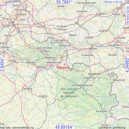
Sebourg GPS coordinates[2]
50° 20' 32.964" North, 3° 38' 36.672" East
| Map corner | latitude | longitude |
|---|---|---|
| Upper-left | 50.7891°, | 2.9404° |
| Center: | 50.34249°, | 3.64352° |
| Lower-right: | 49.89164°, | 4.34665° |
| Map W x H: | 99.8×99.8 km | = 62×62mi |
| max Lat: | 51.07786° ⇑4.1% North |
| Sebourg: | 50.34249° |
| min Lat: | ⇓95.9% South 41.3874° |
| min Long | Sebourg | max Long |
| -5.08615° | 3.64352° | 9.52242° |
| W 65.4%⇐ | ⇒34.6% E |
Elevation
Elevation of Sebourg is 86 m = 282 ft, and this is 107.7 m = 353 ft below average elevation for this country.
| Max E: |
2333 m = 7654 ft | 66.6% |
| Avg. | 193.7 m = 635 ft | |
| Sebourg | 86 m = 282 ft | |
Min E: |
-1 m = -3 ft | 33.4% |
See also: France elevation on elevation.city.
Geographical zone
Sebourg is located in North temperate zone (between Tropic of Cancer and the Arctic Circle). Distance of this North polar circle is 1803.6 km =1120.7 mi to North.| Distance of | km | miles | from Sebourg |
|---|---|---|---|
| North Pole | 4409.5 | 2739.9 | to North |
| Arctic Circle | 1803.6 | 1120.7 | to North |
| Tropic Cancer | 2991.6 | 1858.9 | to South |
| Equator | 5597.6 | 3478.2 | to South |


Nearby cities:
15 places around Sebourg: (largest is in red/bold)
• Curgies
3.2 km =2 mi,  243°
243°
• Estreux
3.6 km =2.2 mi,  285°
285°
• Jenlain
3.6 km =2.2 mi,  197°
197°
• Maresches
7.1 km =4.4 mi,  219°
219°
• Marly
6.7 km =4.2 mi,  272°
272°
• Onnaing
5.7 km =3.5 mi,  327°
327°
• Préseau
6 km =3.7 mi,  234°
234°
• Quarouble
5.1 km =3.2 mi,  343°
343°
• Quiévrechain
5.7 km =3.5 mi,  17°
17°
• Rombies-et-Marchipont
2.5 km =1.6 mi,  356°
356°
• Saint-Saulve
7 km =4.3 mi,  297°
297°
• Saultain
4.7 km =2.9 mi,  262°
262°
• Villers-Pol
6.8 km =4.2 mi, 197°
• Wargnies-le-Grand
4.1 km =2.5 mi,  162°
162°
• Wargnies-le-Petit
5.9 km =3.7 mi, 158°
Sources, notices
• [Note1] Compared only with cities in France existing in our database
• [Src1] Map data: © OpenStreetMap contributors (CC-BY-SA)
• [Src2] Other city data from geonames.org with taken over terms of usage.
• [Src3] Geographical zone / Annual Mean Temperature by Robert A. Rohde @ Wikipedia
