Scaër geodata
Scaër (Brittany) is a populated place; located in France in Europe/Paris (GMT+2) time zone. With population of 5,525 people, there are 1792 cities with bigger population in this country. Compared to other cities in France, 59.8% of cities are located further ↓South; 98.6% of cities are located further →East and 56.8% of cities have lower elevation than Scaër. Note1
Administrative division(s):
- Level 1: Brittany
- Level 2: Département du Finistère
- Level 3: Arrondissement de Quimper
- Level 4: Scaër


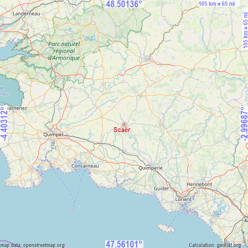
Scaër GPS coordinates[2]
48° 1' 59.988" North, 3° 42' 0" West
| Map corner | latitude | longitude |
|---|---|---|
| Upper-left | 48.50136°, | -4.40312° |
| Center: | 48.03333°, | -3.7° |
| Lower-right: | 47.56101°, | -2.99687° |
| Map W x H: | 104.6×104.6 km | = 65×65mi |
| max Lat: | 51.07786° ⇑40.2% North |
| Scaër: | 48.03333° |
| min Lat: | ⇓59.8% South 41.3874° |
| min Long | Scaër | max Long |
| -5.08615° | -3.7° | 9.52242° |
| W 1.4%⇐ | ⇒98.6% E |
Elevation
Elevation of Scaër is 157 m = 515 ft, and this is 36.7 m = 120 ft below average elevation for this country.
| Max E: |
2333 m = 7654 ft | 43.2% |
| Avg. | 193.7 m = 635 ft | |
| Scaër | 157 m = 515 ft | |
Min E: |
-1 m = -3 ft | 56.8% |
See also: France elevation on elevation.city.
Geographical zone
Scaër is located in North temperate zone (between Tropic of Cancer and the Arctic Circle). Distance of this North polar circle is 2060.4 km =1280.3 mi to North.| Distance of | km | miles | from Scaër |
|---|---|---|---|
| North Pole | 4666.3 | 2899.5 | to North |
| Arctic Circle | 2060.4 | 1280.3 | to North |
| Tropic Cancer | 2734.9 | 1699.4 | to South |
| Equator | 5340.8 | 3318.6 | to South |


Nearby cities:
15 places around Scaër: (largest is in red/bold)
• Bannalec
11.2 km =7 mi,  179°
179°
• Coray
10.1 km =6.3 mi,  286°
286°
• Elliant
14.8 km =9.2 mi,  252°
252°
• Gourin
13.6 km =8.5 mi,  30°
30°
• Guiscriff
4.6 km =2.9 mi,  66°
66°
• Lanvénégen
12.4 km =7.7 mi,  108°
108°
• Laz
15.3 km =9.5 mi,  319°
319°
• Le Saint
12.1 km =7.5 mi,  58°
58°
• Leuhan
9.6 km =6 mi, 319°
• Querrien
14.4 km =8.9 mi,  120°
120°
• Rosporden
12.4 km =7.7 mi,  233°
233°
• Roudouallec
11.2 km =7 mi,  353°
353°
• Saint-Thurien
10.5 km =6.5 mi,  151°
151°
• Tourch
9.9 km =6.2 mi,  270°
270°
• Trégourez
14.4 km =8.9 mi,  300°
300°
Sources, notices
• [Note1] Compared only with cities in France existing in our database
• [Src1] Map data: © OpenStreetMap contributors (CC-BY-SA)
• [Src2] Other city data from geonames.org with taken over terms of usage.
• [Src3] Geographical zone / Annual Mean Temperature by Robert A. Rohde @ Wikipedia
