Le Saint geodata
Le Saint (Brittany) is a populated place; located in France in Europe/Paris (GMT+2) time zone. With population of 749 people, there are 11176 cities with bigger population in this country. Compared to other cities in France, 61% of cities are located further ↓South; 98.4% of cities are located further →East and 59.3% of cities have lower elevation than Le Saint. Note1
Administrative division(s):
- Level 1: Brittany
- Level 2: Morbihan
- Level 3: Arrondissement de Pontivy
- Level 4: Le Saint


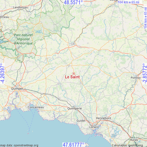
Le Saint GPS coordinates[2]
48° 5' 22.488" North, 3° 33' 39.024" West
| Map corner | latitude | longitude |
|---|---|---|
| Upper-left | 48.5571°, | -4.26397° |
| Center: | 48.08958°, | -3.56084° |
| Lower-right: | 47.61777°, | -2.85772° |
| Map W x H: | 104.4×104.4 km | = 64.9×64.9mi |
| max Lat: | 51.07786° ⇑39% North |
| Le Saint: | 48.08958° |
| min Lat: | ⇓61% South 41.3874° |
| min Long | Le Saint | max Long |
| -5.08615° | -3.56084° | 9.52242° |
| W 1.6%⇐ | ⇒98.4% E |
Elevation
Elevation of Le Saint is 167 m = 548 ft, and this is 26.7 m = 88 ft below average elevation for this country.
| Max E: |
2333 m = 7654 ft | 40.7% |
| Avg. | 193.7 m = 635 ft | |
| Le Saint | 167 m = 548 ft | |
Min E: |
-1 m = -3 ft | 59.3% |
See also: France elevation on elevation.city.
Geographical zone
Le Saint is located in North temperate zone (between Tropic of Cancer and the Arctic Circle). Distance of this North polar circle is 2054.1 km =1276.4 mi to North.| Distance of | km | miles | from Le Saint |
|---|---|---|---|
| North Pole | 4660 | 2895.6 | to North |
| Arctic Circle | 2054.1 | 1276.4 | to North |
| Tropic Cancer | 2741.1 | 1703.2 | to South |
| Equator | 5347.1 | 3322.5 | to South |


Nearby cities:
15 places around Le Saint: (largest is in red/bold)
• Gourin
6.5 km =4 mi,  327°
327°
• Guiscriff
7.6 km =4.7 mi,  234°
234°
• Langonnet
5.3 km =3.3 mi,  70°
70°
• Lanvénégen
10.3 km =6.4 mi,  171°
171°
• Le Croisty
14.9 km =9.3 mi,  100°
100°
• Le Faouët
8.2 km =5.1 mi,  140°
140°
• Meslan
14.2 km =8.8 mi, 137°
• Motreff
12.4 km =7.7 mi,  2°
2°
• Plouray
14.4 km =8.9 mi,  64°
64°
• Plévin
14.8 km =9.2 mi,  17°
17°
• Priziac
11 km =6.8 mi, 103°
• Querrien
13.8 km =8.6 mi, 171°
• Roudouallec
12.5 km =7.8 mi,  292°
292°
• Saint-Hernin
15.1 km =9.4 mi,  339°
339°
• Scaër
12.1 km =7.5 mi,  238°
238°
Sources, notices
• [Note1] Compared only with cities in France existing in our database
• [Src1] Map data: © OpenStreetMap contributors (CC-BY-SA)
• [Src2] Other city data from geonames.org with taken over terms of usage.
• [Src3] Geographical zone / Annual Mean Temperature by Robert A. Rohde @ Wikipedia
