Gourin geodata
Gourin (Brittany) is a populated place; located in France in Europe/Paris (GMT+2) time zone. With population of 5,005 people, there are 1979 cities with bigger population in this country. Compared to other cities in France, 61.8% of cities are located further ↓South; 98.5% of cities are located further →East and 56.3% of cities have lower elevation than Gourin. Note1
Administrative division(s):
- Level 1: Brittany
- Level 2: Morbihan
- Level 3: Arrondissement de Pontivy
- Level 4: Gourin


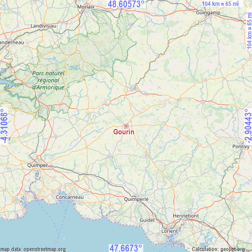
Gourin GPS coordinates[2]
48° 8' 19.176" North, 3° 36' 27.18" West
| Map corner | latitude | longitude |
|---|---|---|
| Upper-left | 48.60573°, | -4.31068° |
| Center: | 48.13866°, | -3.60755° |
| Lower-right: | 47.6673°, | -2.90443° |
| Map W x H: | 104.3×104.3 km | = 64.8×64.8mi |
| max Lat: | 51.07786° ⇑38.2% North |
| Gourin: | 48.13866° |
| min Lat: | ⇓61.8% South 41.3874° |
| min Long | Gourin | max Long |
| -5.08615° | -3.60755° | 9.52242° |
| W 1.5%⇐ | ⇒98.5% E |
Elevation
Elevation of Gourin is 155 m = 509 ft, and this is 38.7 m = 127 ft below average elevation for this country.
| Max E: |
2333 m = 7654 ft | 43.7% |
| Avg. | 193.7 m = 635 ft | |
| Gourin | 155 m = 509 ft | |
Min E: |
-1 m = -3 ft | 56.3% |
See also: France elevation on elevation.city.
Geographical zone
Gourin is located in North temperate zone (between Tropic of Cancer and the Arctic Circle). Distance of this North polar circle is 2048.7 km =1273 mi to North.| Distance of | km | miles | from Gourin |
|---|---|---|---|
| North Pole | 4654.5 | 2892.2 | to North |
| Arctic Circle | 2048.7 | 1273 | to North |
| Tropic Cancer | 2746.6 | 1706.7 | to South |
| Equator | 5352.5 | 3325.9 | to South |


Nearby cities:
15 places around Gourin: (largest is in red/bold)
• Cléden-Poher
11.8 km =7.3 mi,  337°
337°
• Guiscriff
10.3 km =6.4 mi,  195°
195°
• Kergloff
15.1 km =9.4 mi,  356°
356°
• Landeleau
13.3 km =8.3 mi,  317°
317°
• Langonnet
9.2 km =5.7 mi,  113°
113°
• Le Faouët
14.6 km =9.1 mi,  143°
143°
• Le Saint
6.5 km =4 mi,  147°
147°
• Leuhan
13.8 km =8.6 mi,  251°
251°
• Motreff
8 km =5 mi,  29°
29°
• Plévin
11.8 km =7.3 mi,  42°
42°
• Roudouallec
8.1 km =5 mi,  265°
265°
• Saint-Goazec
13.4 km =8.3 mi,  283°
283°
• Saint-Hernin
8.9 km =5.5 mi,  347°
347°
• Scaër
13.6 km =8.5 mi,  210°
210°
• Spézet
10.6 km =6.6 mi,  310°
310°
Sources, notices
• [Note1] Compared only with cities in France existing in our database
• [Src1] Map data: © OpenStreetMap contributors (CC-BY-SA)
• [Src2] Other city data from geonames.org with taken over terms of usage.
• [Src3] Geographical zone / Annual Mean Temperature by Robert A. Rohde @ Wikipedia
