Savigny geodata
Savigny (Auvergne-Rhône-Alpes) is a populated place; located in France in Europe/Paris (GMT+2) time zone. With population of 664 people, there are 12308 cities with bigger population in this country. Compared to other cities in France, 65.5% of cities are located further ↑North; 86.6% of cities are located further ←West and 94.5% of cities have lower elevation than Savigny. Note1
Administrative division(s):
- Level 1: Auvergne-Rhône-Alpes
- Level 2: Haute-Savoie
- Level 3: Arrondissement de Saint-Julien-en-Genevois
- Level 4: Savigny


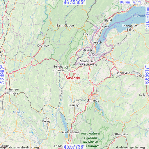
Savigny GPS coordinates[2]
46° 4' 2.532" North, 5° 57' 10.98" East
| Map corner | latitude | longitude |
|---|---|---|
| Upper-left | 46.55305°, | 5.24992° |
| Center: | 46.06737°, | 5.95305° |
| Lower-right: | 45.57738°, | 6.65617° |
| Map W x H: | 108.5×108.5 km | = 67.4×67.4mi |
| max Lat: | 51.07786° ⇑65.5% North |
| Savigny: | 46.06737° |
| min Lat: | ⇓34.5% South 41.3874° |
| min Long | Savigny | max Long |
| -5.08615° | 5.95305° | 9.52242° |
| W 86.6%⇐ | ⇒13.4% E |
Elevation
Elevation of Savigny is 561 m = 1841 ft, and this is 367.3 m = 1205 ft above average elevation for this country.
| Max E: |
2333 m = 7654 ft | 5.5% |
| Savigny | 561 m 1841 ft | |
| Avg. | 193.7 m = 635 ft | |
Min E: |
-1 m = -3 ft | 94.5% |
See also: France elevation on elevation.city.
Geographical zone
Savigny is located in North temperate zone (between Tropic of Cancer and the Arctic Circle). Distance of this North polar circle is 2279 km =1416.1 mi to North.| Distance of | km | miles | from Savigny |
|---|---|---|---|
| North Pole | 4884.9 | 3035.3 | to North |
| Arctic Circle | 2279 | 1416.1 | to North |
| Tropic Cancer | 2516.3 | 1563.6 | to South |
| Equator | 5122.2 | 3182.8 | to South |


Nearby cities:
15 places around Savigny: (largest is in red/bold)
• Andilly
8.7 km =5.4 mi,  96°
96°
• Cercier
8.7 km =5.4 mi,  121°
121°
• Cernex
7.4 km =4.6 mi,  93°
93°
• Chilly
8.4 km =5.2 mi,  179°
179°
• Frangy
5.5 km =3.4 mi,  196°
196°
• Jonzier
3 km =1.9 mi,  81°
81°
• Léaz
6.4 km =4 mi,  301°
301°
• Minzier
3.3 km =2.1 mi, 123°
• Pougny
8.1 km =5 mi,  358°
358°
• Sallenôves
7.7 km =4.8 mi,  153°
153°
• Valleiry
5 km =3.1 mi,  15°
15°
• Vers
6.5 km =4 mi,  68°
68°
• Viry
8.3 km =5.2 mi,  52°
52°
• Vulbens
4.1 km =2.5 mi,  339°
339°
• Éloise
7.3 km =4.5 mi,  281°
281°
Sources, notices
• [Note1] Compared only with cities in France existing in our database
• [Src1] Map data: © OpenStreetMap contributors (CC-BY-SA)
• [Src2] Other city data from geonames.org with taken over terms of usage.
• [Src3] Geographical zone / Annual Mean Temperature by Robert A. Rohde @ Wikipedia
