Éloise geodata
Éloise (Auvergne-Rhône-Alpes) is a populated place; located in France in Europe/Paris (GMT+2) time zone. With population of 774 people, there are 10892 cities with bigger population in this country. Compared to other cities in France, 65.3% of cities are located further ↑North; 85.6% of cities are located further ←West and 93.3% of cities have lower elevation than Éloise. Note1
Administrative division(s):
- Level 1: Auvergne-Rhône-Alpes
- Level 2: Haute-Savoie
- Level 3: Arrondissement de Saint-Julien-en-Genevois
- Level 4: Éloise


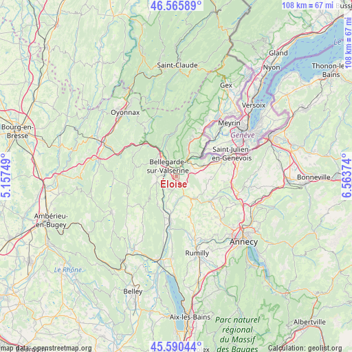
Éloise GPS coordinates[2]
46° 4' 49.152" North, 5° 51' 38.196" East
| Map corner | latitude | longitude |
|---|---|---|
| Upper-left | 46.56589°, | 5.15749° |
| Center: | 46.08032°, | 5.86061° |
| Lower-right: | 45.59044°, | 6.56374° |
| Map W x H: | 108.5×108.5 km | = 67.4×67.4mi |
| max Lat: | 51.07786° ⇑65.3% North |
| Éloise: | 46.08032° |
| min Lat: | ⇓34.7% South 41.3874° |
| min Long | Éloise | max Long |
| -5.08615° | 5.86061° | 9.52242° |
| W 85.6%⇐ | ⇒14.4% E |
Elevation
Elevation of Éloise is 515 m = 1690 ft, and this is 321.3 m = 1054 ft above average elevation for this country.
| Max E: |
2333 m = 7654 ft | 6.7% |
| Éloise | 515 m 1690 ft | |
| Avg. | 193.7 m = 635 ft | |
Min E: |
-1 m = -3 ft | 93.3% |
See also: France elevation on elevation.city.
Geographical zone
Éloise is located in North temperate zone (between Tropic of Cancer and the Arctic Circle). Distance of this North polar circle is 2277.5 km =1415.2 mi to North.| Distance of | km | miles | from Éloise |
|---|---|---|---|
| North Pole | 4883.4 | 3034.4 | to North |
| Arctic Circle | 2277.5 | 1415.2 | to North |
| Tropic Cancer | 2517.7 | 1564.4 | to South |
| Equator | 5123.7 | 3183.7 | to South |


Nearby cities:
15 places around Éloise: (largest is in red/bold)
• Bellegarde-sur-Valserine
4.2 km =2.6 mi,  317°
317°
• Châtillon-en-Michaille
8.4 km =5.2 mi,  326°
326°
• Collonges
7.3 km =4.5 mi,  28°
28°
• Confort
8.3 km =5.2 mi,  339°
339°
• Desingy
9.7 km =6 mi,  167°
167°
• Farges
10.2 km =6.3 mi,  19°
19°
• Frangy
8.7 km =5.4 mi,  140°
140°
• Génissiat
5.5 km =3.4 mi,  235°
235°
• Jonzier
10.2 km =6.3 mi,  95°
95°
• Lancrans
5.6 km =3.5 mi, 337°
• Léaz
2.6 km =1.6 mi,  40°
40°
• Pougny
9.5 km =5.9 mi,  45°
45°
• Savigny
7.3 km =4.5 mi, 101°
• Valleiry
9.1 km =5.7 mi,  68°
68°
• Vulbens
6.1 km =3.8 mi, 67°
Sources, notices
• [Note1] Compared only with cities in France existing in our database
• [Src1] Map data: © OpenStreetMap contributors (CC-BY-SA)
• [Src2] Other city data from geonames.org with taken over terms of usage.
• [Src3] Geographical zone / Annual Mean Temperature by Robert A. Rohde @ Wikipedia
