Frangy geodata
Frangy (Auvergne-Rhône-Alpes) is a populated place; located in France in Europe/Paris (GMT+2) time zone. With population of 1,779 people, there are 5333 cities with bigger population in this country. Compared to other cities in France, 66% of cities are located further ↑North; 86.3% of cities are located further ←West and 87.3% of cities have lower elevation than Frangy. Note1
Administrative division(s):
- Level 1: Auvergne-Rhône-Alpes
- Level 2: Haute-Savoie
- Level 3: Arrondissement de Saint-Julien-en-Genevois
- Level 4: Frangy


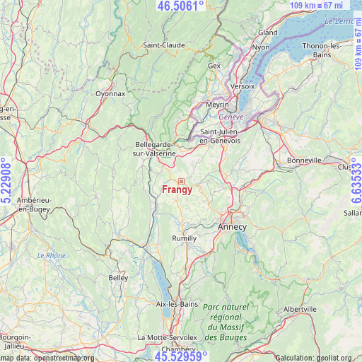
Frangy GPS coordinates[2]
46° 1' 12" North, 5° 55' 55.92" East
| Map corner | latitude | longitude |
|---|---|---|
| Upper-left | 46.5061°, | 5.22908° |
| Center: | 46.02°, | 5.9322° |
| Lower-right: | 45.52959°, | 6.63533° |
| Map W x H: | 108.6×108.6 km | = 67.5×67.5mi |
| max Lat: | 51.07786° ⇑66% North |
| Frangy: | 46.02° |
| min Lat: | ⇓34% South 41.3874° |
| min Long | Frangy | max Long |
| -5.08615° | 5.9322° | 9.52242° |
| W 86.3%⇐ | ⇒13.7% E |
Elevation
Elevation of Frangy is 379 m = 1243 ft, and this is 185.3 m = 608 ft above average elevation for this country.
| Max E: |
2333 m = 7654 ft | 12.7% |
| Frangy | 379 m 1243 ft | |
| Avg. | 193.7 m = 635 ft | |
Min E: |
-1 m = -3 ft | 87.3% |
See also: France elevation on elevation.city.
Geographical zone
Frangy is located in North temperate zone (between Tropic of Cancer and the Arctic Circle). Distance of this North polar circle is 2284.2 km =1419.3 mi to North.| Distance of | km | miles | from Frangy |
|---|---|---|---|
| North Pole | 4890.1 | 3038.6 | to North |
| Arctic Circle | 2284.2 | 1419.3 | to North |
| Tropic Cancer | 2511 | 1560.3 | to South |
| Equator | 5116.9 | 3179.5 | to South |


Nearby cities:
15 places around Frangy: (largest is in red/bold)
• Cercier
9 km =5.6 mi,  85°
85°
• Chilly
3.6 km =2.2 mi,  150°
150°
• Desingy
4.4 km =2.7 mi,  231°
231°
• Jonzier
7.3 km =4.5 mi,  38°
38°
• Léaz
9.5 km =5.9 mi,  336°
336°
• Menthonnex-sous-Clermont
6.2 km =3.9 mi,  178°
178°
• Minzier
5.5 km =3.4 mi,  51°
51°
• Mésigny
6.5 km =4 mi,  121°
121°
• Sallenôves
5.3 km =3.3 mi,  108°
108°
• Savigny
5.5 km =3.4 mi,  16°
16°
• Seyssel
10 km =6.2 mi, 227°
• Thusy
8.4 km =5.2 mi,  168°
168°
• Versonnex
10.1 km =6.3 mi, 182°
• Vulbens
9.1 km =5.7 mi,  0°
0°
• Éloise
8.7 km =5.4 mi,  320°
320°
Sources, notices
• [Note1] Compared only with cities in France existing in our database
• [Src1] Map data: © OpenStreetMap contributors (CC-BY-SA)
• [Src2] Other city data from geonames.org with taken over terms of usage.
• [Src3] Geographical zone / Annual Mean Temperature by Robert A. Rohde @ Wikipedia
