Sassenage geodata
Sassenage (Auvergne-Rhône-Alpes) is a populated place; located in France in Europe/Paris (GMT+2) time zone. With population of 10,641 people, there are 895 cities with bigger population in this country. Compared to other cities in France, 77.3% of cities are located further ↑North; 84.1% of cities are located further ←West and 67.4% of cities have lower elevation than Sassenage. Note1
Administrative division(s):
- Level 1: Auvergne-Rhône-Alpes
- Level 2: Département de l'Isère
- Level 3: Arrondissement de Grenoble
- Level 4: Sassenage


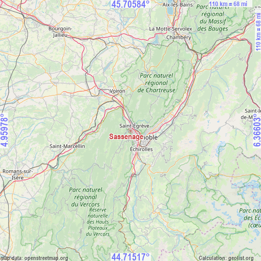
Sassenage GPS coordinates[2]
45° 12' 45.576" North, 5° 39' 46.44" East
| Map corner | latitude | longitude |
|---|---|---|
| Upper-left | 45.70584°, | 4.95978° |
| Center: | 45.21266°, | 5.6629° |
| Lower-right: | 44.71517°, | 6.36603° |
| Map W x H: | 110.2×110.2 km | = 68.5×68.5mi |
| max Lat: | 51.07786° ⇑77.3% North |
| Sassenage: | 45.21266° |
| min Lat: | ⇓22.7% South 41.3874° |
| min Long | Sassenage | max Long |
| -5.08615° | 5.6629° | 9.52242° |
| W 84.1%⇐ | ⇒15.9% E |
Elevation
Elevation of Sassenage is 206 m = 676 ft, and this is 12.3 m = 40 ft above average elevation for this country.
| Max E: |
2333 m = 7654 ft | 32.6% |
| Sassenage | 206 m 676 ft | |
| Avg. | 193.7 m = 635 ft | |
Min E: |
-1 m = -3 ft | 67.4% |
See also: France elevation on elevation.city.
Geographical zone
Sassenage is located in North temperate zone (between Tropic of Cancer and the Arctic Circle). Distance of this North polar circle is 2374 km =1475.1 mi to North.| Distance of | km | miles | from Sassenage |
|---|---|---|---|
| North Pole | 4979.9 | 3094.4 | to North |
| Arctic Circle | 2374 | 1475.1 | to North |
| Tropic Cancer | 2421.3 | 1504.5 | to South |
| Equator | 5027.2 | 3123.8 | to South |


Nearby cities:
15 places around Sassenage: (largest is in red/bold)
• Corenc
8 km =5 mi,  85°
85°
• Fontaine
3 km =1.9 mi,  138°
138°
• Fontanil-Cornillon
4.5 km =2.8 mi,  0°
0°
• Grenoble
5.5 km =3.4 mi,  132°
132°
• La Tronche
6.6 km =4.1 mi,  97°
97°
• Noyarey
4.2 km =2.6 mi,  326°
326°
• Proveysieux
5.9 km =3.7 mi,  26°
26°
• Quaix-en-Chartreuse
5.9 km =3.7 mi,  45°
45°
• Saint-Martin-le-Vinoux
4.3 km =2.7 mi, 104°
• Saint-Nizier-du-Moucherotte
5.3 km =3.3 mi,  208°
208°
• Saint-Égrève
2.7 km =1.7 mi, 32°
• Seyssinet-Pariset
4.7 km =2.9 mi,  148°
148°
• Seyssins
5.9 km =3.7 mi,  161°
161°
• Veurey-Voroize
7.7 km =4.8 mi, 330°
• Échirolles
8.4 km =5.2 mi, 151°
Sources, notices
• [Note1] Compared only with cities in France existing in our database
• [Src1] Map data: © OpenStreetMap contributors (CC-BY-SA)
• [Src2] Other city data from geonames.org with taken over terms of usage.
• [Src3] Geographical zone / Annual Mean Temperature by Robert A. Rohde @ Wikipedia
