Ennetières-en-Weppes geodata
Ennetières-en-Weppes (Hauts-de-France) is a populated place; located in France in Europe/Paris (GMT+2) time zone. With population of 1,154 people, there are 7803 cities with bigger population in this country. Compared to other cities in France, 98.4% of cities are located further ↓South; 57% of cities are located further ←West and 84.9% of cities have higher elevation than Ennetières-en-Weppes. Note1
Administrative division(s):
- Level 1: Hauts-de-France
- Level 2: Nord
- Level 3: Arrondissement de Lille
- Level 4: Ennetières-en-Weppes
Current local time in Ennetières-en-Weppes:
06:00 AM, WednesdayDifference from your time zone: hours


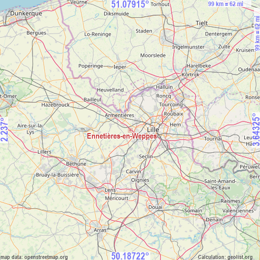
Ennetières-en-Weppes GPS coordinates[2]
50° 38' 7.08" North, 2° 56' 24.432" East
| Map corner | latitude | longitude |
|---|---|---|
| Upper-left | 51.07915°, | 2.237° |
| Center: | 50.6353°, | 2.94012° |
| Lower-right: | 50.18722°, | 3.64325° |
| Map W x H: | 99.2×99.2 km | = 61.6×61.6mi |
| max Lat: | 51.07786° ⇑1.6% North |
| Ennetières-en-Weppes: | 50.6353° |
| min Lat: | ⇓98.4% South 41.3874° |
| min Long | Ennetières-en- | max Long |
| -5.08615° | 2.94012° | 9.52242° |
| W 57%⇐ | ⇒43% E |
Elevation
Elevation of Ennetières-en-Weppes is 42 m = 138 ft, and this is 151.7 m = 498 ft below average elevation for this country.
| Max E: |
2333 m = 7654 ft | 84.9% |
| Avg. | 193.7 m = 635 ft | |
| Ennetières-en-Weppes | 42 m = 138 ft | |
Min E: |
-1 m = -3 ft | 15.1% |
See also: France elevation on elevation.city.
Geographical zone
Ennetières-en-Weppes is located in North temperate zone (between Tropic of Cancer and the Arctic Circle). Distance of this North polar circle is 1771.1 km =1100.5 mi to North.| Distance of | km | miles | from Ennetières-en-Weppes |
|---|---|---|---|
| North Pole | 4376.9 | 2719.7 | to North |
| Arctic Circle | 1771.1 | 1100.5 | to North |
| Tropic Cancer | 3024.2 | 1879.2 | to South |
| Equator | 5630.1 | 3498.4 | to South |


Nearby cities:
15 places around Ennetières-en-Weppes: (largest is in red/bold)
• Beaucamps-Ligny
3.7 km =2.3 mi,  207°
207°
• Bois-Grenier
4.9 km =3 mi,  289°
289°
• Capinghem
1.9 km =1.2 mi,  53°
53°
• Englos
1.5 km =0.9 mi,  128°
128°
• Hallennes-lez-Haubourdin
2.8 km =1.7 mi,  137°
137°
• Haubourdin
4.7 km =2.9 mi, 129°
• Le Maisnil
4.5 km =2.8 mi,  239°
239°
• Lomme
3.4 km =2.1 mi,  74°
74°
• Lompret
5.1 km =3.2 mi,  42°
42°
• Loos
6.2 km =3.9 mi,  117°
117°
• Prémesques
2.4 km =1.5 mi,  19°
19°
• Pérenchies
4.4 km =2.7 mi,  28°
28°
• Radinghem-en-Weppes
2.8 km =1.7 mi,  229°
229°
• Santes
5 km =3.1 mi,  161°
161°
• Sequedin
3.2 km =2 mi,  109°
109°
Sources, notices
• [Note1] Compared only with cities in France existing in our database
• [Src1] Map data: © OpenStreetMap contributors (CC-BY-SA)
• [Src2] Other city data from geonames.org with taken over terms of usage.
• [Src3] Geographical zone / Annual Mean Temperature by Robert A. Rohde @ Wikipedia
