Vimont geodata
Vimont (Normandy) is a populated place; located in France in Europe/Paris (GMT+2) time zone. With population of 543 people, there are 14333 cities with bigger population in this country. Compared to other cities in France, 82.7% of cities are located further ↓South; 79.6% of cities are located further →East and 92.4% of cities have higher elevation than Vimont. Note1
Administrative division(s):
- Level 1: Normandy
- Level 2: Calvados
- Level 3: Arrondissement de Caen
- Level 4: Vimont


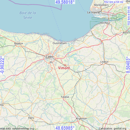
Vimont GPS coordinates[2]
49° 7' 19.74" North, 0° 11' 56.76" West
| Map corner | latitude | longitude |
|---|---|---|
| Upper-left | 49.58018°, | -0.90222° |
| Center: | 49.12215°, | -0.1991° |
| Lower-right: | 48.65985°, | 0.50403° |
| Map W x H: | 102.3×102.3 km | = 63.6×63.6mi |
| max Lat: | 51.07786° ⇑17.3% North |
| Vimont: | 49.12215° |
| min Lat: | ⇓82.7% South 41.3874° |
| min Long | Vimont | max Long |
| -5.08615° | -0.1991° | 9.52242° |
| W 20.4%⇐ | ⇒79.6% E |
Elevation
Elevation of Vimont is 24 m = 79 ft, and this is 169.7 m = 557 ft below average elevation for this country.
| Max E: |
2333 m = 7654 ft | 92.4% |
| Avg. | 193.7 m = 635 ft | |
| Vimont | 24 m = 79 ft | |
Min E: |
-1 m = -3 ft | 7.6% |
See also: France elevation on elevation.city.
Geographical zone
Vimont is located in North temperate zone (between Tropic of Cancer and the Arctic Circle). Distance of this North polar circle is 1939.3 km =1205 mi to North.| Distance of | km | miles | from Vimont |
|---|---|---|---|
| North Pole | 4545.2 | 2824.3 | to North |
| Arctic Circle | 1939.3 | 1205 | to North |
| Tropic Cancer | 2856 | 1774.6 | to South |
| Equator | 5461.9 | 3393.9 | to South |


Nearby cities:
15 places around Vimont: (largest is in red/bold)
• Airan
4.2 km =2.6 mi,  124°
124°
• Argences
2.4 km =1.5 mi,  78°
78°
• Bellengreville
0.8 km =0.5 mi,  286°
286°
• Bourguébus
7.2 km =4.5 mi,  269°
269°
• Cagny
4.9 km =3 mi,  302°
302°
• Chicheboville
1.8 km =1.1 mi,  219°
219°
• Démouville
8.2 km =5.1 mi,  321°
321°
• Garcelles-Secqueville
7.1 km =4.4 mi,  248°
248°
• Grentheville
7 km =4.3 mi, 294°
• Moult
2.6 km =1.6 mi,  107°
107°
• Méry-Corbon
8.6 km =5.3 mi, 80°
• Saint-Sylvain
7.5 km =4.7 mi,  190°
190°
• Sannerville
6.7 km =4.2 mi,  344°
344°
• Soliers
7.2 km =4.5 mi,  280°
280°
• Troarn
6.4 km =4 mi,  11°
11°
Sources, notices
• [Note1] Compared only with cities in France existing in our database
• [Src1] Map data: © OpenStreetMap contributors (CC-BY-SA)
• [Src2] Other city data from geonames.org with taken over terms of usage.
• [Src3] Geographical zone / Annual Mean Temperature by Robert A. Rohde @ Wikipedia
