Condette geodata
Condette (Hauts-de-France) is a populated place; located in France in Europe/Paris (GMT+2) time zone. With population of 2,764 people, there are 3535 cities with bigger population in this country. Compared to other cities in France, 98.5% of cities are located further ↓South; 61.2% of cities are located further →East and 72.3% of cities have higher elevation than Condette. Note1
Administrative division(s):
- Level 1: Hauts-de-France
- Level 2: Pas-de-Calais
- Level 3: Arrondissement de Boulogne-sur-Mer
- Level 4: Condette


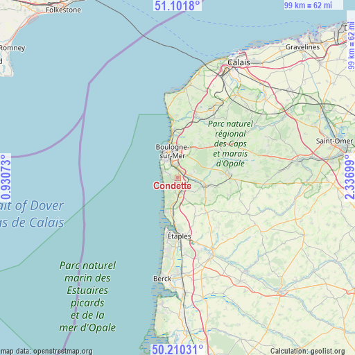
Condette GPS coordinates[2]
50° 39' 29.412" North, 1° 38' 1.896" East
| Map corner | latitude | longitude |
|---|---|---|
| Upper-left | 51.1018°, | 0.93073° |
| Center: | 50.65817°, | 1.63386° |
| Lower-right: | 50.21031°, | 2.33699° |
| Map W x H: | 99.1×99.1 km | = 61.6×61.6mi |
| max Lat: | 51.07786° ⇑1.5% North |
| Condette: | 50.65817° |
| min Lat: | ⇓98.5% South 41.3874° |
| min Long | Condette | max Long |
| -5.08615° | 1.63386° | 9.52242° |
| W 38.8%⇐ | ⇒61.2% E |
Elevation
Elevation of Condette is 73 m = 240 ft, and this is 120.7 m = 396 ft below average elevation for this country.
| Max E: |
2333 m = 7654 ft | 72.3% |
| Avg. | 193.7 m = 635 ft | |
| Condette | 73 m = 240 ft | |
Min E: |
-1 m = -3 ft | 27.7% |
See also: France elevation on elevation.city.
Geographical zone
Condette is located in North temperate zone (between Tropic of Cancer and the Arctic Circle). Distance of this North polar circle is 1768.5 km =1098.9 mi to North.| Distance of | km | miles | from Condette |
|---|---|---|---|
| North Pole | 4374.4 | 2718.1 | to North |
| Arctic Circle | 1768.5 | 1098.9 | to North |
| Tropic Cancer | 3026.7 | 1880.7 | to South |
| Equator | 5632.7 | 3500 | to South |


Nearby cities:
15 places around Condette: (largest is in red/bold)
• Baincthun
6.6 km =4.1 mi,  29°
29°
• Boulogne-sur-Mer
7.6 km =4.7 mi,  349°
349°
• Carly
4.9 km =3 mi,  98°
98°
• Dannes
7.9 km =4.9 mi,  190°
190°
• Hesdigneul-lès-Boulogne
2 km =1.2 mi,  80°
80°
• Isques
2.3 km =1.4 mi,  39°
39°
• Le Portel
6.7 km =4.2 mi,  322°
322°
• Nesles
3.9 km =2.4 mi,  156°
156°
• Neufchâtel-Hardelot
4.3 km =2.7 mi,  172°
172°
• Outreau
6.1 km =3.8 mi,  329°
329°
• Saint-Léonard
3.7 km =2.3 mi, 350°
• Saint-Martin-Boulogne
7.7 km =4.8 mi, 352°
• Saint-Étienne-au-Mont
2.2 km =1.4 mi, 354°
• Samer
8.2 km =5.1 mi,  105°
105°
• Équihen-Plage
4.8 km =3 mi,  294°
294°
Sources, notices
• [Note1] Compared only with cities in France existing in our database
• [Src1] Map data: © OpenStreetMap contributors (CC-BY-SA)
• [Src2] Other city data from geonames.org with taken over terms of usage.
• [Src3] Geographical zone / Annual Mean Temperature by Robert A. Rohde @ Wikipedia
