Salon-la-Tour geodata
Salon-la-Tour (Nouvelle-Aquitaine) is a populated place; located in France in Europe/Paris (GMT+2) time zone. With population of 739 people, there are 11303 cities with bigger population in this country. Compared to other cities in France, 74.1% of cities are located further ↑North; 62.5% of cities are located further →East and 88.4% of cities have lower elevation than Salon-la-Tour. Note1
Administrative division(s):
- Level 1: Nouvelle-Aquitaine
- Level 2: Département de la Corrèze
- Level 3: Arrondissement de Tulle
- Level 4: Salon-la-Tour


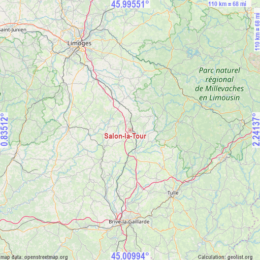
Salon-la-Tour GPS coordinates[2]
45° 30' 17.568" North, 1° 32' 17.7" East
| Map corner | latitude | longitude |
|---|---|---|
| Upper-left | 45.99551°, | 0.83512° |
| Center: | 45.50488°, | 1.53825° |
| Lower-right: | 45.00994°, | 2.24137° |
| Map W x H: | 109.6×109.6 km | = 68.1×68.1mi |
| max Lat: | 51.07786° ⇑74.1% North |
| Salon-la-Tour: | 45.50488° |
| min Lat: | ⇓25.9% South 41.3874° |
| min Long | Salon-la-Tour | max Long |
| -5.08615° | 1.53825° | 9.52242° |
| W 37.5%⇐ | ⇒62.5% E |
Elevation
Elevation of Salon-la-Tour is 395 m = 1296 ft, and this is 201.3 m = 660 ft above average elevation for this country.
| Max E: |
2333 m = 7654 ft | 11.6% |
| Salon-la-Tour | 395 m 1296 ft | |
| Avg. | 193.7 m = 635 ft | |
Min E: |
-1 m = -3 ft | 88.4% |
See also: France elevation on elevation.city.
Geographical zone
Salon-la-Tour is located in North temperate zone (between Tropic of Cancer and the Arctic Circle). Distance of this North polar circle is 2341.5 km =1454.9 mi to North.| Distance of | km | miles | from Salon-la-Tour |
|---|---|---|---|
| North Pole | 4947.4 | 3074.2 | to North |
| Arctic Circle | 2341.5 | 1454.9 | to North |
| Tropic Cancer | 2453.7 | 1524.7 | to South |
| Equator | 5059.7 | 3144 | to South |


Nearby cities:
15 places around Salon-la-Tour: (largest is in red/bold)
• Condat-sur-Ganaveix
6 km =3.7 mi,  133°
133°
• Eyburie
9.1 km =5.7 mi,  123°
123°
• La Croisille-sur-Briance
14.3 km =8.9 mi,  13°
13°
• La Porcherie
8.5 km =5.3 mi,  3°
3°
• Lubersac
12.4 km =7.7 mi,  237°
237°
• Magnac-Bourg
15.1 km =9.4 mi,  326°
326°
• Masseret
4.7 km =2.9 mi,  343°
343°
• Meilhards
10.5 km =6.5 mi,  54°
54°
• Meuzac
9.3 km =5.8 mi,  305°
305°
• Saint-Germain-les-Belles
12.7 km =7.9 mi, 344°
• Saint-Jal
14.6 km =9.1 mi,  145°
145°
• Saint-Ybard
6.5 km =4 mi,  191°
191°
• Troche
15.1 km =9.4 mi,  210°
210°
• Uzerche
9.1 km =5.7 mi,  167°
167°
• Vigeois
14.1 km =8.8 mi, 186°
Sources, notices
• [Note1] Compared only with cities in France existing in our database
• [Src1] Map data: © OpenStreetMap contributors (CC-BY-SA)
• [Src2] Other city data from geonames.org with taken over terms of usage.
• [Src3] Geographical zone / Annual Mean Temperature by Robert A. Rohde @ Wikipedia
