Condat-sur-Ganaveix geodata
Condat-sur-Ganaveix (Nouvelle-Aquitaine) is a populated place; located in France in Europe/Paris (GMT+2) time zone. With population of 647 people, there are 12562 cities with bigger population in this country. Compared to other cities in France, 74.5% of cities are located further ↑North; 61.8% of cities are located further →East and 86.6% of cities have lower elevation than Condat-sur-Ganaveix. Note1
Administrative division(s):
- Level 1: Nouvelle-Aquitaine
- Level 2: Département de la Corrèze
- Level 3: Arrondissement de Tulle
- Level 4: Condat-sur-Ganaveix


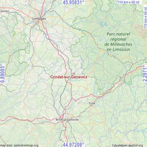
Condat-sur-Ganaveix GPS coordinates[2]
45° 28' 2.46" North, 1° 35' 38.328" East
| Map corner | latitude | longitude |
|---|---|---|
| Upper-left | 45.95831°, | 0.89085° |
| Center: | 45.46735°, | 1.59398° |
| Lower-right: | 44.97208°, | 2.2971° |
| Map W x H: | 109.7×109.7 km | = 68.2×68.2mi |
| max Lat: | 51.07786° ⇑74.5% North |
| Condat-sur-Ganaveix: | 45.46735° |
| min Lat: | ⇓25.5% South 41.3874° |
| min Long | Condat-sur-Gana | max Long |
| -5.08615° | 1.59398° | 9.52242° |
| W 38.2%⇐ | ⇒61.8% E |
Elevation
Elevation of Condat-sur-Ganaveix is 368 m = 1207 ft, and this is 174.3 m = 572 ft above average elevation for this country.
| Max E: |
2333 m = 7654 ft | 13.4% |
| Condat-sur-Ganaveix | 368 m 1207 ft | |
| Avg. | 193.7 m = 635 ft | |
Min E: |
-1 m = -3 ft | 86.6% |
See also: France elevation on elevation.city.
Geographical zone
Condat-sur-Ganaveix is located in North temperate zone (between Tropic of Cancer and the Arctic Circle). Distance of this North polar circle is 2345.7 km =1457.5 mi to North.| Distance of | km | miles | from Condat-sur-Ganaveix |
|---|---|---|---|
| North Pole | 4951.6 | 3076.8 | to North |
| Arctic Circle | 2345.7 | 1457.5 | to North |
| Tropic Cancer | 2449.6 | 1522.1 | to South |
| Equator | 5055.5 | 3141.3 | to South |


Nearby cities:
15 places around Condat-sur-Ganaveix: (largest is in red/bold)
• Chamboulive
9.5 km =5.9 mi,  114°
114°
• Eyburie
3.4 km =2.1 mi,  104°
104°
• La Porcherie
13.2 km =8.2 mi,  342°
342°
• Lagraulière
13.2 km =8.2 mi,  164°
164°
• Le Lonzac
10.5 km =6.5 mi,  92°
92°
• Lubersac
15 km =9.3 mi,  260°
260°
• Masseret
10.4 km =6.5 mi,  326°
326°
• Meilhards
11.1 km =6.9 mi,  22°
22°
• Saint-Jal
8.8 km =5.5 mi,  153°
153°
• Saint-Ybard
6 km =3.7 mi,  249°
249°
• Salon-la-Tour
6 km =3.7 mi,  313°
313°
• Seilhac
14.5 km =9 mi,  140°
140°
• Troche
14.8 km =9.2 mi,  233°
233°
• Uzerche
5.3 km =3.3 mi,  206°
206°
• Vigeois
11.5 km =7.1 mi, 211°
Sources, notices
• [Note1] Compared only with cities in France existing in our database
• [Src1] Map data: © OpenStreetMap contributors (CC-BY-SA)
• [Src2] Other city data from geonames.org with taken over terms of usage.
• [Src3] Geographical zone / Annual Mean Temperature by Robert A. Rohde @ Wikipedia
