Eyburie geodata
Eyburie (Nouvelle-Aquitaine) is a populated place; located in France in Europe/Paris (GMT+2) time zone. With population of 505 people, there are 15148 cities with bigger population in this country. Compared to other cities in France, 74.5% of cities are located further ↑North; 61.2% of cities are located further →East and 90.3% of cities have lower elevation than Eyburie. Note1
Administrative division(s):
- Level 1: Nouvelle-Aquitaine
- Level 2: Département de la Corrèze
- Level 3: Arrondissement de Tulle
- Level 4: Eyburie


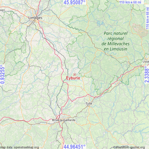
Eyburie GPS coordinates[2]
45° 27' 35.46" North, 1° 38' 8.412" East
| Map corner | latitude | longitude |
|---|---|---|
| Upper-left | 45.95087°, | 0.93255° |
| Center: | 45.45985°, | 1.63567° |
| Lower-right: | 44.96451°, | 2.3388° |
| Map W x H: | 109.7×109.7 km | = 68.2×68.2mi |
| max Lat: | 51.07786° ⇑74.5% North |
| Eyburie: | 45.45985° |
| min Lat: | ⇓25.5% South 41.3874° |
| min Long | Eyburie | max Long |
| -5.08615° | 1.63567° | 9.52242° |
| W 38.8%⇐ | ⇒61.2% E |
Elevation
Elevation of Eyburie is 434 m = 1424 ft, and this is 240.3 m = 788 ft above average elevation for this country.
| Max E: |
2333 m = 7654 ft | 9.7% |
| Eyburie | 434 m 1424 ft | |
| Avg. | 193.7 m = 635 ft | |
Min E: |
-1 m = -3 ft | 90.3% |
See also: France elevation on elevation.city.
Geographical zone
Eyburie is located in North temperate zone (between Tropic of Cancer and the Arctic Circle). Distance of this North polar circle is 2346.5 km =1458 mi to North.| Distance of | km | miles | from Eyburie |
|---|---|---|---|
| North Pole | 4952.4 | 3077.3 | to North |
| Arctic Circle | 2346.5 | 1458 | to North |
| Tropic Cancer | 2448.7 | 1521.6 | to South |
| Equator | 5054.7 | 3140.8 | to South |


Nearby cities:
15 places around Eyburie: (largest is in red/bold)
• Chamberet
15.2 km =9.4 mi,  25°
25°
• Chamboulive
6.2 km =3.9 mi,  119°
119°
• Condat-sur-Ganaveix
3.4 km =2.1 mi,  284°
284°
• Lagraulière
11.9 km =7.4 mi,  178°
178°
• Le Lonzac
7.3 km =4.5 mi,  86°
86°
• Masseret
13.1 km =8.1 mi,  316°
316°
• Meilhards
11.1 km =6.9 mi,  5°
5°
• Saint-Clément
13.7 km =8.5 mi,  163°
163°
• Saint-Jal
7.1 km =4.4 mi, 175°
• Saint-Ybard
9 km =5.6 mi,  261°
261°
• Salon-la-Tour
9.1 km =5.7 mi,  303°
303°
• Seilhac
12 km =7.5 mi,  149°
149°
• Treignac
15.1 km =9.4 mi,  55°
55°
• Uzerche
6.9 km =4.3 mi,  235°
235°
• Vigeois
12.9 km =8 mi,  225°
225°
Sources, notices
• [Note1] Compared only with cities in France existing in our database
• [Src1] Map data: © OpenStreetMap contributors (CC-BY-SA)
• [Src2] Other city data from geonames.org with taken over terms of usage.
• [Src3] Geographical zone / Annual Mean Temperature by Robert A. Rohde @ Wikipedia
