Saint-Yrieix-la-Perche geodata
Saint-Yrieix-la-Perche (Nouvelle-Aquitaine) is a populated place; located in France in Europe/Paris (GMT+2) time zone. With population of 7,895 people, there are 1229 cities with bigger population in this country. Compared to other cities in France, 74% of cities are located further ↑North; 66.7% of cities are located further →East and 87.9% of cities have lower elevation than Saint-Yrieix-la-Perche. Note1
Administrative division(s):
- Level 1: Nouvelle-Aquitaine
- Level 2: Haute-Vienne
- Level 3: Arrondissement de Limoges
- Level 4: Saint-Yrieix-la-Perche
Current local time in Saint-Yrieix-la-Perche:
09:20 AM, SaturdayDifference from your time zone: hours


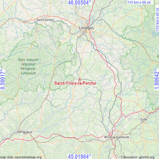
Saint-Yrieix-la-Perche GPS coordinates[2]
45° 30' 52.2" North, 1° 12' 11.844" East
| Map corner | latitude | longitude |
|---|---|---|
| Upper-left | 46.00504°, | 0.50017° |
| Center: | 45.5145°, | 1.20329° |
| Lower-right: | 45.01964°, | 1.90642° |
| Map W x H: | 109.6×109.6 km | = 68.1×68.1mi |
| max Lat: | 51.07786° ⇑74% North |
| Saint-Yrieix-la-Perche: | 45.5145° |
| min Lat: | ⇓26% South 41.3874° |
| min Long | Saint-Yrieix-la | max Long |
| -5.08615° | 1.20329° | 9.52242° |
| W 33.3%⇐ | ⇒66.7% E |
Elevation
Elevation of Saint-Yrieix-la-Perche is 388 m = 1273 ft, and this is 194.3 m = 637 ft above average elevation for this country.
| Max E: |
2333 m = 7654 ft | 12.1% |
| Saint-Yrieix-la-Perche | 388 m 1273 ft | |
| Avg. | 193.7 m = 635 ft | |
Min E: |
-1 m = -3 ft | 87.9% |
See also: France elevation on elevation.city.
Geographical zone
Saint-Yrieix-la-Perche is located in North temperate zone (between Tropic of Cancer and the Arctic Circle). Distance of this North polar circle is 2340.4 km =1454.3 mi to North.| Distance of | km | miles | from Saint-Yrieix-la-Perche |
|---|---|---|---|
| North Pole | 4946.3 | 3073.5 | to North |
| Arctic Circle | 2340.4 | 1454.3 | to North |
| Tropic Cancer | 2454.8 | 1525.3 | to South |
| Equator | 5060.7 | 3144.6 | to South |


Nearby cities:
15 places around Saint-Yrieix-la-Perche: (largest is in red/bold)
• Angoisse
11 km =6.8 mi,  207°
207°
• Arnac-Pompadour
17.5 km =10.9 mi,  131°
131°
• Château-Chervix
15.6 km =9.7 mi,  48°
48°
• Coussac-Bonneval
9.4 km =5.8 mi,  92°
92°
• Glandon
4.2 km =2.6 mi,  155°
155°
• Jumilhac-le-Grand
11.1 km =6.9 mi,  258°
258°
• La Meyze
11.4 km =7.1 mi,  4°
4°
• Ladignac-le-Long
10.3 km =6.4 mi,  317°
317°
• Lanouaille
14.2 km =8.8 mi,  200°
200°
• Lubersac
17.5 km =10.9 mi,  116°
116°
• Payzac
12.8 km =8 mi,  175°
175°
• Saint-Hilaire-les-Places
14.9 km =9.3 mi,  346°
346°
• Saint-Paul-la-Roche
16.5 km =10.3 mi, 255°
• Saint-Priest-Ligoure
16.7 km =10.4 mi,  24°
24°
• Savignac-Lédrier
16.8 km =10.4 mi, 175°
Sources, notices
• [Note1] Compared only with cities in France existing in our database
• [Src1] Map data: © OpenStreetMap contributors (CC-BY-SA)
• [Src2] Other city data from geonames.org with taken over terms of usage.
• [Src3] Geographical zone / Annual Mean Temperature by Robert A. Rohde @ Wikipedia
