Chamelet geodata
Chamelet (Auvergne-Rhône-Alpes) is a populated place; located in France in Europe/Paris (GMT+2) time zone. With population of 614 people, there are 13088 cities with bigger population in this country. Compared to other cities in France, 66.4% of cities are located further ↑North; 72.2% of cities are located further ←West and 92% of cities have lower elevation than Chamelet. Note1
Administrative division(s):
- Level 1: Auvergne-Rhône-Alpes
- Level 2: Département du Rhône
- Level 3: Arrondissement de Villefranche-sur-Saône
- Level 4: Chamelet


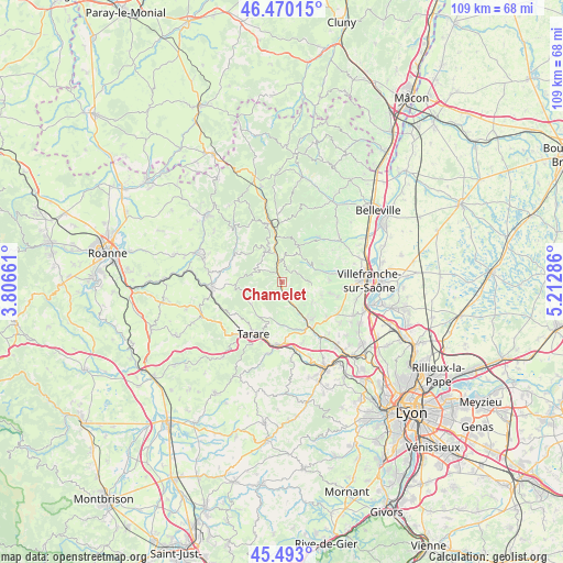
Chamelet GPS coordinates[2]
45° 59' 1.428" North, 4° 30' 35.064" East
| Map corner | latitude | longitude |
|---|---|---|
| Upper-left | 46.47015°, | 3.80661° |
| Center: | 45.98373°, | 4.50974° |
| Lower-right: | 45.493°, | 5.21286° |
| Map W x H: | 108.6×108.6 km | = 67.5×67.5mi |
| max Lat: | 51.07786° ⇑66.4% North |
| Chamelet: | 45.98373° |
| min Lat: | ⇓33.6% South 41.3874° |
| min Long | Chamelet | max Long |
| -5.08615° | 4.50974° | 9.52242° |
| W 72.2%⇐ | ⇒27.8% E |
Elevation
Elevation of Chamelet is 477 m = 1565 ft, and this is 283.3 m = 929 ft above average elevation for this country.
| Max E: |
2333 m = 7654 ft | 8% |
| Chamelet | 477 m 1565 ft | |
| Avg. | 193.7 m = 635 ft | |
Min E: |
-1 m = -3 ft | 92% |
See also: France elevation on elevation.city.
Geographical zone
Chamelet is located in North temperate zone (between Tropic of Cancer and the Arctic Circle). Distance of this North polar circle is 2288.3 km =1421.9 mi to North.| Distance of | km | miles | from Chamelet |
|---|---|---|---|
| North Pole | 4894.2 | 3041.1 | to North |
| Arctic Circle | 2288.3 | 1421.9 | to North |
| Tropic Cancer | 2507 | 1557.8 | to South |
| Equator | 5112.9 | 3177 | to South |


Nearby cities:
15 places around Chamelet: (largest is in red/bold)
• Chambost-Allières
3.9 km =2.4 mi,  347°
347°
• Cogny
8.9 km =5.5 mi,  87°
87°
• Grandris
6.6 km =4.1 mi,  336°
336°
• Jarnioux
9.3 km =5.8 mi,  103°
103°
• Lamure-sur-Azergues
8.9 km =5.5 mi, 351°
• Le Bois-d'Oingt
9.3 km =5.8 mi,  142°
142°
• Létra
2.6 km =1.6 mi,  154°
154°
• Oingt
6.9 km =4.3 mi,  124°
124°
• Rivolet
7.5 km =4.7 mi,  70°
70°
• Saint-Clément-sur-Valsonne
7.9 km =4.9 mi,  212°
212°
• Saint-Laurent-d’Oingt
6 km =3.7 mi, 136°
• Saint-Vérand
7.3 km =4.5 mi,  169°
169°
• Ternand
4.6 km =2.9 mi,  161°
161°
• Valsonne
7.5 km =4.7 mi,  236°
236°
• Ville-sur-Jarnioux
8 km =5 mi,  107°
107°
Sources, notices
• [Note1] Compared only with cities in France existing in our database
• [Src1] Map data: © OpenStreetMap contributors (CC-BY-SA)
• [Src2] Other city data from geonames.org with taken over terms of usage.
• [Src3] Geographical zone / Annual Mean Temperature by Robert A. Rohde @ Wikipedia
