Rieux-en-Cambrésis geodata
Rieux-en-Cambrésis (Hauts-de-France) is a populated place; located in France in Europe/Paris (GMT+2) time zone. With population of 1,397 people, there are 6621 cities with bigger population in this country. Compared to other cities in France, 94.9% of cities are located further ↓South; 62.7% of cities are located further ←West and 80.2% of cities have higher elevation than Rieux-en-Cambrésis. Note1
Administrative division(s):
- Level 1: Hauts-de-France
- Level 2: Nord
- Level 3: Arrondissement de Cambrai
- Level 4: Rieux-en-Cambrésis


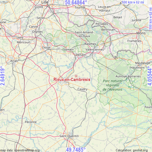
Rieux-en-Cambrésis GPS coordinates[2]
50° 12' 2.484" North, 3° 21' 8.352" East
| Map corner | latitude | longitude |
|---|---|---|
| Upper-left | 50.64864°, | 2.64919° |
| Center: | 50.20069°, | 3.35232° |
| Lower-right: | 49.7485°, | 4.05544° |
| Map W x H: | 100.1×100.1 km | = 62.2×62.2mi |
| max Lat: | 51.07786° ⇑5.1% North |
| Rieux-en-Cambrésis: | 50.20069° |
| min Lat: | ⇓94.9% South 41.3874° |
| min Long | Rieux-en-Cambr� | max Long |
| -5.08615° | 3.35232° | 9.52242° |
| W 62.7%⇐ | ⇒37.3% E |
Elevation
Elevation of Rieux-en-Cambrésis is 54 m = 177 ft, and this is 139.7 m = 458 ft below average elevation for this country.
| Max E: |
2333 m = 7654 ft | 80.2% |
| Avg. | 193.7 m = 635 ft | |
| Rieux-en-Cambrésis | 54 m = 177 ft | |
Min E: |
-1 m = -3 ft | 19.8% |
See also: France elevation on elevation.city.
Geographical zone
Rieux-en-Cambrésis is located in North temperate zone (between Tropic of Cancer and the Arctic Circle). Distance of this North polar circle is 1819.4 km =1130.5 mi to North.| Distance of | km | miles | from Rieux-en-Cambrésis |
|---|---|---|---|
| North Pole | 4425.3 | 2749.8 | to North |
| Arctic Circle | 1819.4 | 1130.5 | to North |
| Tropic Cancer | 2975.9 | 1849.1 | to South |
| Equator | 5581.8 | 3468.4 | to South |


Nearby cities:
15 places around Rieux-en-Cambrésis: (largest is in red/bold)
• Avesnes-le-Sec
5.9 km =3.7 mi,  17°
17°
• Avesnes-les-Aubert
2.2 km =1.4 mi,  91°
91°
• Awoingt
7.1 km =4.4 mi,  225°
225°
• Bévillers
5.5 km =3.4 mi,  150°
150°
• Carnières
3.6 km =2.2 mi,  185°
185°
• Cauroir
4.7 km =2.9 mi, 229°
• Escaudœuvres
6.1 km =3.8 mi,  269°
269°
• Iwuy
4.2 km =2.6 mi,  327°
327°
• Naves
2.6 km =1.6 mi,  275°
275°
• Quiévy
6.5 km =4 mi,  123°
123°
• Ramillies
6.5 km =4 mi, 274°
• Saint-Aubert
4.7 km =2.9 mi,  79°
79°
• Saint-Hilaire-lez-Cambrai
4.7 km =2.9 mi,  112°
112°
• Saint-Vaast-en-Cambrésis
4.6 km =2.9 mi, 90°
• Villers-en-Cauchies
4.6 km =2.9 mi,  52°
52°
Sources, notices
• [Note1] Compared only with cities in France existing in our database
• [Src1] Map data: © OpenStreetMap contributors (CC-BY-SA)
• [Src2] Other city data from geonames.org with taken over terms of usage.
• [Src3] Geographical zone / Annual Mean Temperature by Robert A. Rohde @ Wikipedia
