Saint-Symphorien-le-Château geodata
Saint-Symphorien-le-Château (Centre) is a populated place; located in France in Europe/Paris (GMT+2) time zone. With population of 864 people, there are 9950 cities with bigger population in this country. Compared to other cities in France, 68.8% of cities are located further ↓South; 59.9% of cities are located further →East and 54.5% of cities have lower elevation than Saint-Symphorien-le-Château. Note1
Administrative division(s):
- Level 1: Centre
- Level 2: Département d'Eure-et-Loir
- Level 3: Arrondissement de Chartres
- Level 4: Auneau-Bleury-Saint-Symphorien
Current local time in Saint-Symphorien-le-Château:
01:44 PM, WednesdayDifference from your time zone: hours


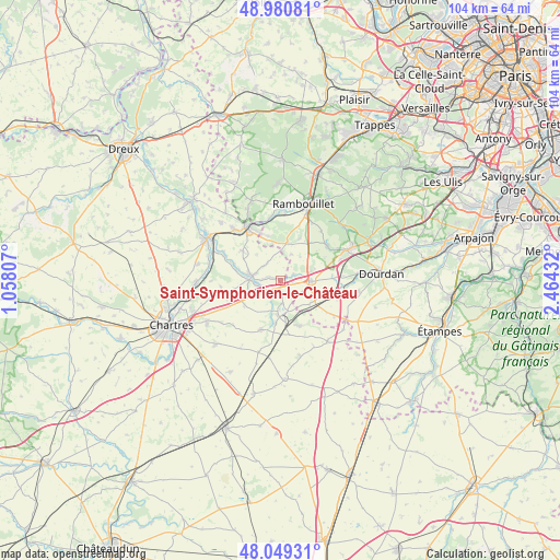
Saint-Symphorien-le-Château GPS coordinates[2]
48° 31' 1.92" North, 1° 45' 40.32" East
| Map corner | latitude | longitude |
|---|---|---|
| Upper-left | 48.98081°, | 1.05807° |
| Center: | 48.5172°, | 1.7612° |
| Lower-right: | 48.04931°, | 2.46432° |
| Map W x H: | 103.6×103.6 km | = 64.4×64.4mi |
| max Lat: | 51.07786° ⇑31.2% North |
| Saint-Symphorien-le-Château: | 48.5172° |
| min Lat: | ⇓68.8% South 41.3874° |
| min Long | Saint-Symphorie | max Long |
| -5.08615° | 1.7612° | 9.52242° |
| W 40.1%⇐ | ⇒59.9% E |
Elevation
Elevation of Saint-Symphorien-le-Château is 148 m = 486 ft, and this is 45.7 m = 150 ft below average elevation for this country.
| Max E: |
2333 m = 7654 ft | 45.5% |
| Avg. | 193.7 m = 635 ft | |
| Saint-Symphorien-le-Château | 148 m = 486 ft | |
Min E: |
-1 m = -3 ft | 54.5% |
See also: France elevation on elevation.city.
Geographical zone
Saint-Symphorien-le-Château is located in North temperate zone (between Tropic of Cancer and the Arctic Circle). Distance of this North polar circle is 2006.6 km =1246.8 mi to North.| Distance of | km | miles | from Saint-Symphorien-le-Château |
|---|---|---|---|
| North Pole | 4612.5 | 2866.1 | to North |
| Arctic Circle | 2006.6 | 1246.8 | to North |
| Tropic Cancer | 2788.7 | 1732.8 | to South |
| Equator | 5394.6 | 3352 | to South |


Nearby cities:
15 places around Saint-Symphorien-le-Château: (largest is in red/bold)
• Ablis
5.5 km =3.4 mi,  90°
90°
• Armenonville-les-Gâtineaux
8.9 km =5.5 mi,  289°
289°
• Aunay-sous-Auneau
9.2 km =5.7 mi,  156°
156°
• Auneau
6 km =3.7 mi,  171°
171°
• Béville-le-Comte
9.7 km =6 mi,  201°
201°
• Droue-sur-Drouette
10.3 km =6.4 mi,  334°
334°
• Gallardon
5.1 km =3.2 mi,  281°
281°
• Gas
8.9 km =5.5 mi,  308°
308°
• Le Gué-de-Longroi
3.5 km =2.2 mi,  239°
239°
• Orcemont
8.7 km =5.4 mi,  24°
24°
• Orphin
6.9 km =4.3 mi,  11°
11°
• Sonchamp
10.8 km =6.7 mi,  52°
52°
• Ymeray
4.6 km =2.9 mi,  259°
259°
• Écrosnes
4 km =2.5 mi,  323°
323°
• Émancé
8.4 km =5.2 mi,  344°
344°
Sources, notices
• [Note1] Compared only with cities in France existing in our database
• [Src1] Map data: © OpenStreetMap contributors (CC-BY-SA)
• [Src2] Other city data from geonames.org with taken over terms of usage.
• [Src3] Geographical zone / Annual Mean Temperature by Robert A. Rohde @ Wikipedia
