Burie geodata
Burie (Nouvelle-Aquitaine) is a populated place; located in France in Europe/Paris (GMT+2) time zone. With population of 1,355 people, there are 6787 cities with bigger population in this country. Compared to other cities in France, 69.7% of cities are located further ↑North; 82.4% of cities are located further →East and 77% of cities have higher elevation than Burie. Note1
Administrative division(s):
- Level 1: Nouvelle-Aquitaine
- Level 2: Charente-Maritime
- Level 3: Arrondissement de Saintes
- Level 4: Burie


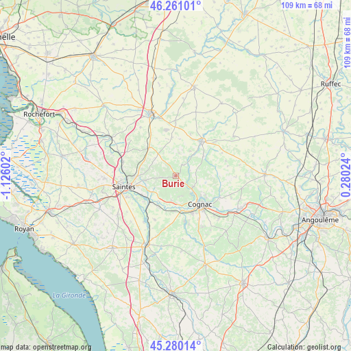
Burie GPS coordinates[2]
45° 46' 21.828" North, 0° 25' 22.404" West
| Map corner | latitude | longitude |
|---|---|---|
| Upper-left | 46.26101°, | -1.12602° |
| Center: | 45.77273°, | -0.42289° |
| Lower-right: | 45.28014°, | 0.28024° |
| Map W x H: | 109.1×109.1 km | = 67.8×67.8mi |
| max Lat: | 51.07786° ⇑69.7% North |
| Burie: | 45.77273° |
| min Lat: | ⇓30.3% South 41.3874° |
| min Long | Burie | max Long |
| -5.08615° | -0.42289° | 9.52242° |
| W 17.6%⇐ | ⇒82.4% E |
Elevation
Elevation of Burie is 62 m = 203 ft, and this is 131.7 m = 432 ft below average elevation for this country.
| Max E: |
2333 m = 7654 ft | 77% |
| Avg. | 193.7 m = 635 ft | |
| Burie | 62 m = 203 ft | |
Min E: |
-1 m = -3 ft | 23% |
See also: France elevation on elevation.city.
Geographical zone
Burie is located in North temperate zone (between Tropic of Cancer and the Arctic Circle). Distance of this North polar circle is 2311.7 km =1436.4 mi to North.| Distance of | km | miles | from Burie |
|---|---|---|---|
| North Pole | 4917.6 | 3055.7 | to North |
| Arctic Circle | 2311.7 | 1436.4 | to North |
| Tropic Cancer | 2483.5 | 1543.2 | to South |
| Equator | 5089.5 | 3162.5 | to South |


Nearby cities:
15 places around Burie: (largest is in red/bold)
• Brizambourg
7.1 km =4.4 mi,  321°
321°
• Cherves-Richemont
6.5 km =4 mi,  120°
120°
• Chérac
7.7 km =4.8 mi,  189°
189°
• Cognac
11.2 km =7 mi,  139°
139°
• Javrezac
9.9 km =6.2 mi,  145°
145°
• La Chapelle-des-Pots
9.3 km =5.8 mi,  261°
261°
• Merpins
10.1 km =6.3 mi,  169°
169°
• Migron
3.9 km =2.4 mi,  32°
32°
• Saint-Laurent-de-Cognac
8.5 km =5.3 mi, 172°
• Saint-Sauvant
7.4 km =4.6 mi,  239°
239°
• Saint-Sever-de-Saintonge
10.1 km =6.3 mi,  216°
216°
• Saint-Sulpice-de-Cognac
3.6 km =2.2 mi,  113°
113°
• Salignac-sur-Charente
11.2 km =7 mi,  182°
182°
• Vénérand
10.6 km =6.6 mi,  282°
282°
• Écoyeux
8.4 km =5.2 mi,  310°
310°
Sources, notices
• [Note1] Compared only with cities in France existing in our database
• [Src1] Map data: © OpenStreetMap contributors (CC-BY-SA)
• [Src2] Other city data from geonames.org with taken over terms of usage.
• [Src3] Geographical zone / Annual Mean Temperature by Robert A. Rohde @ Wikipedia
